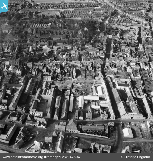
EAW047604 ENGLAND (1952). Rant Score and environs, Lowestoft, 1952
© Copyright OpenStreetMap contributors and licensed by the OpenStreetMap Foundation. 2024. Cartography is licensed as CC BY-SA.
Nearby Images (12)
Details
| Title | [EAW047604] Rant Score and environs, Lowestoft, 1952 |
| Reference | EAW047604 |
| Date | 23-October-1952 |
| Link | |
| Place name | LOWESTOFT |
| Parish | |
| District | |
| Country | ENGLAND |
| Easting / Northing | 655166, 293621 |
| Longitude / Latitude | 1.7582880863385, 52.480368452707 |
| National Grid Reference | TM552936 |
Pins
 Harvey |
Saturday 1st of July 2023 02:17:19 PM | |
 Harvey |
Saturday 1st of July 2023 02:11:45 PM | |
 Harvey |
Saturday 1st of July 2023 01:57:30 PM | |
 Eddy |
Monday 18th of October 2021 09:37:18 PM | |
 peterjt |
Tuesday 24th of February 2015 04:42:03 PM | |
 Brightonboy |
Monday 18th of August 2014 09:05:20 PM | |
 Brightonboy |
Monday 18th of August 2014 09:03:46 PM |


![[EAW047604] Rant Score and environs, Lowestoft, 1952](http://britainfromabove.org.uk/sites/all/libraries/aerofilms-images/public/100x100/EAW/047/EAW047604.jpg)
![[EAW047607] Rant Score and environs, Lowestoft, 1952. This image was marked by Aerofilms Ltd for photo editing.](http://britainfromabove.org.uk/sites/all/libraries/aerofilms-images/public/100x100/EAW/047/EAW047607.jpg)
![[EAW047602] Rant Score and environs, Lowestoft, 1952. This image was marked by Aerofilms Ltd for photo editing.](http://britainfromabove.org.uk/sites/all/libraries/aerofilms-images/public/100x100/EAW/047/EAW047602.jpg)
![[EAW047606] Rant Score and environs, Lowestoft, 1952. This image was marked by Aerofilms Ltd for photo editing.](http://britainfromabove.org.uk/sites/all/libraries/aerofilms-images/public/100x100/EAW/047/EAW047606.jpg)
![[EAW047603] Rant Score and environs, Lowestoft, 1952. This image was marked by Aerofilms Ltd for photo editing.](http://britainfromabove.org.uk/sites/all/libraries/aerofilms-images/public/100x100/EAW/047/EAW047603.jpg)
![[EAW047600] Rant Score and environs, Lowestoft, 1952. This image was marked by Aerofilms Ltd for photo editing.](http://britainfromabove.org.uk/sites/all/libraries/aerofilms-images/public/100x100/EAW/047/EAW047600.jpg)
![[EAW047599] Whapload Road and environs, Lowestoft, 1952. This image was marked by Aerofilms Ltd for photo editing.](http://britainfromabove.org.uk/sites/all/libraries/aerofilms-images/public/100x100/EAW/047/EAW047599.jpg)
![[EAW047598] Rant Score and environs, Lowestoft, 1952. This image was marked by Aerofilms Ltd for photo editing.](http://britainfromabove.org.uk/sites/all/libraries/aerofilms-images/public/100x100/EAW/047/EAW047598.jpg)
![[EAW047601] Rant Score and environs, Lowestoft, 1952. This image was marked by Aerofilms Ltd for photo editing.](http://britainfromabove.org.uk/sites/all/libraries/aerofilms-images/public/100x100/EAW/047/EAW047601.jpg)
![[EAW047605] Rant Score and environs, Lowestoft, 1952. This image was marked by Aerofilms Ltd for photo editing.](http://britainfromabove.org.uk/sites/all/libraries/aerofilms-images/public/100x100/EAW/047/EAW047605.jpg)
![[EPW021249] Old Market Plain and St Peter's Church, Lowestoft, 1928](http://britainfromabove.org.uk/sites/all/libraries/aerofilms-images/public/100x100/EPW/021/EPW021249.jpg)
![[EPW060824] Lowestoft Water and Gas Co Gas Works on Ness Point and environs, Lowestoft, 1939](http://britainfromabove.org.uk/sites/all/libraries/aerofilms-images/public/100x100/EPW/060/EPW060824.jpg)


.jpg?itok=x7PxJ5sU)