
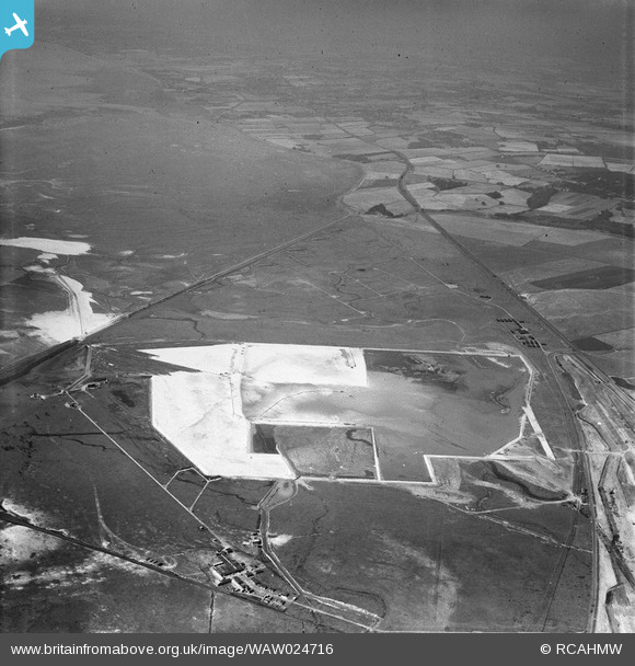
WAW024716 WALES (1949). View of the dredging of the Shotton steelworks site (commissioned by Westminster Dredging Co.)
© Copyright OpenStreetMap contributors and licensed by the OpenStreetMap Foundation. 2024. Cartography is licensed as CC BY-SA.
Nearby Images (48)
WAW024712
")
WAW024713
")
WAW024714
")
WAW024715
")
WAW024716
")
WAW024717
")
WAW024718
")
WAW024719
")
WAW024720
")
WAW024721
")
WAW024722
")
WAW027362
. Oblique aerial photograph, 5½\" cut roll film.")
WAW027366

WAW027367

WAW027370

WAW027382
. Oblique aerial photograph, 5½\" cut roll film.")
WAW027383
. Oblique aerial photograph, 5½\" cut roll film.")
WAW027384
. Oblique aerial photograph, 5½\" cut roll film.")
WAW030308

WAW030309

WAW030310

WAW030311

WAW030312

WAW030313

WAW030314

WAW030315

WAW030316
, for Shotton Steelworks commissioned by the Westminster Dredging Co. Ltd")
WAW030317
, for Shotton Steelworks commissioned by the Westminster Dredging Co. Ltd")
WAW030318
, for Shotton Steelworks commissioned by the Westminster Dredging Co. Ltd")
WAW030319

WAW030320

WAW030321

WAW030322

WAW030323

WAW030324

WAW030325

WAW030326

WAW030327

WAW030328

WAW030329

WAW030330

WAW030331

WAW030332

WAW030333
, for Shotton Steelworks commissioned by the Westminster Dredging Co. Ltd")
WAW030334

WAW030335

WAW030336

WAW030337

Details
| Title | [WAW024716] View of the dredging of the Shotton steelworks site (commissioned by Westminster Dredging Co.) |
| Reference | WAW024716 |
| Date | 12-July-1949 |
| Link | Coflein Archive Item 6414078 |
| Place name | |
| Parish | |
| District | |
| Country | WALES |
| Easting / Northing | 330500, 370500 |
| Longitude / Latitude | -3.0411853684416, 53.226709296404 |
| National Grid Reference | SJ305705 |
Pins
Be the first to add a comment to this image!
User Comment Contributions
This area is now the UPM paperworks, Broken Bank is the diagonal line across the top left. White line bottom left was pert of the Sealand rifle range and is now covered up. |
 e10694 |
Monday 3rd of November 2014 08:36:15 PM |