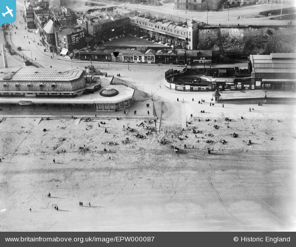
EPW000087 ENGLAND (1920). Ramsgate Harbour Station, Ramsgate, 1920
© Hawlfraint cyfranwyr OpenStreetMap a thrwyddedwyd gan yr OpenStreetMap Foundation. 2025. Trwyddedir y gartograffeg fel CC BY-SA.
Delweddau cyfagos (48)
Manylion
| Pennawd | [EPW000087] Ramsgate Harbour Station, Ramsgate, 1920 |
| Cyfeirnod | EPW000087 |
| Dyddiad | February-1920 |
| Dolen | |
| Enw lle | RAMSGATE |
| Plwyf | RAMSGATE |
| Ardal | |
| Gwlad | ENGLAND |
| Dwyreiniad / Gogleddiad | 638639, 164785 |
| Hydred / Lledred | 1.4261298203946, 51.33149339705 |
| Cyfeirnod Grid Cenedlaethol | TR386648 |
Pinnau
 ie |
Tuesday 14th of May 2024 01:28:26 AM | |
 Gen_Hancock |
Thursday 9th of February 2017 11:56:37 AM | |
 EZTD |
Wednesday 27th of June 2012 11:28:11 PM | |
 EZTD |
Wednesday 27th of June 2012 10:03:03 PM |
Cyfraniadau Grŵp
The Army operated a Driver Training School in Ramsgate during World War 2. My Father was based there for 5 weeks. A member of the Ramsgate History Forum suggested that this School may have been located at the Railway Station. Perhaps it was at the disused Station featuring in the picture "Ramsgate Harbour Station". Can anyone verify this? |
 Robbo |
Friday 27th of May 2016 08:53:09 AM |
 MM |
Thursday 21st of March 2013 09:36:56 AM | |
Opened in 1863 as part of the Kent Coast Railway company's extension of its line from Herne Bay, it was conveniently situated for the seaside resort's beach, but it closed in 1926 after a reorganisation of railway lines in the Thanet area. |
 Buzby9 |
Sunday 7th of October 2012 08:25:55 PM |


![[EPW000087] Ramsgate Harbour Station, Ramsgate, 1920](http://britainfromabove.org.uk/sites/all/libraries/aerofilms-images/public/100x100/EPW/000/EPW000087.jpg)
![[EPW039325] The Royal Victoria Pavilion and 'Pleasurama', Ramsgate, 1932](http://britainfromabove.org.uk/sites/all/libraries/aerofilms-images/public/100x100/EPW/039/EPW039325.jpg)
![[EPW009172] The Harbour Station and Royal Victoria Pavilion, Ramsgate, 1923](http://britainfromabove.org.uk/sites/all/libraries/aerofilms-images/public/100x100/EPW/009/EPW009172.jpg)
![[EPW009173] The Harbour Station and Royal Victoria Pavilion, Ramsgate, 1923](http://britainfromabove.org.uk/sites/all/libraries/aerofilms-images/public/100x100/EPW/009/EPW009173.jpg)
![[EPW035453] Wellington Crescent Gardens, the Royal Victoria Pavilion and Ramsgate Sands, Ramsgate, 1931](http://britainfromabove.org.uk/sites/all/libraries/aerofilms-images/public/100x100/EPW/035/EPW035453.jpg)
![[EAW024843] The Royal Victoria Pavilion and environs, Ramsgate, 1949](http://britainfromabove.org.uk/sites/all/libraries/aerofilms-images/public/100x100/EAW/024/EAW024843.jpg)
![[EAW006169] Ramsgate Sands, Wellington Crescent and environs, Ramsgate, 1947](http://britainfromabove.org.uk/sites/all/libraries/aerofilms-images/public/100x100/EAW/006/EAW006169.jpg)
![[EAW009051] Crowds at the Royal Victoria Pavilion and Ramsgate Sands, Ramsgate, 1947](http://britainfromabove.org.uk/sites/all/libraries/aerofilms-images/public/100x100/EAW/009/EAW009051.jpg)
![[EPW039324] The Royal Victoria Pavilion, Ramsgate, 1932](http://britainfromabove.org.uk/sites/all/libraries/aerofilms-images/public/100x100/EPW/039/EPW039324.jpg)
![[EAW009056] Ramsgate Sands, the Ramsgate Olympia and the town, Ramsgate, 1947](http://britainfromabove.org.uk/sites/all/libraries/aerofilms-images/public/100x100/EAW/009/EAW009056.jpg)
![[EAW009058] Ramsgate Sands, the Ramsgate Olympia and the town, Ramsgate, 1947](http://britainfromabove.org.uk/sites/all/libraries/aerofilms-images/public/100x100/EAW/009/EAW009058.jpg)
![[EAW024842] The beach and Marina Esplanade, Ramsgate, 1949](http://britainfromabove.org.uk/sites/all/libraries/aerofilms-images/public/100x100/EAW/024/EAW024842.jpg)
![[EAW006166] The Olympia, Ramsgate, 1947](http://britainfromabove.org.uk/sites/all/libraries/aerofilms-images/public/100x100/EAW/006/EAW006166.jpg)
![[EPW000093] Ramsgate Harbour Station, Ramsgate, 1920](http://britainfromabove.org.uk/sites/all/libraries/aerofilms-images/public/100x100/EPW/000/EPW000093.jpg)
![[EAW009014] Crowds on Ramsgate Sands, the Royal Victoria Pavilion and Wellington Crescent, Ramsgate, 1947](http://britainfromabove.org.uk/sites/all/libraries/aerofilms-images/public/100x100/EAW/009/EAW009014.jpg)
![[EAW024844] Ramsgate Olympia "Merrie England", Ramsgate, 1949](http://britainfromabove.org.uk/sites/all/libraries/aerofilms-images/public/100x100/EAW/024/EAW024844.jpg)
![[EPW009174] The Harbour Station and Royal Victoria Pavilion and environs, Ramsgate, 1923](http://britainfromabove.org.uk/sites/all/libraries/aerofilms-images/public/100x100/EPW/009/EPW009174.jpg)
![[EPW042859] The Royal Victoria Pavilion, 'Pleasurama' and the town, Ramsgate, from the east, 1933](http://britainfromabove.org.uk/sites/all/libraries/aerofilms-images/public/100x100/EPW/042/EPW042859.jpg)
![[EPW048783] Harbour Parade, the seafront and town, Ramsgate, from the south, 1935](http://britainfromabove.org.uk/sites/all/libraries/aerofilms-images/public/100x100/EPW/048/EPW048783.jpg)
![[EAW006170] Ramsgate Sands, Wellington Crescent and the town, Ramsgate, from the south-east, 1947](http://britainfromabove.org.uk/sites/all/libraries/aerofilms-images/public/100x100/EAW/006/EAW006170.jpg)
![[EAW009057] Ramsgate Sands, the Marina and the town, Ramsgate, 1947](http://britainfromabove.org.uk/sites/all/libraries/aerofilms-images/public/100x100/EAW/009/EAW009057.jpg)
![[EAW006171] Ramsgate Sands, Wellington Crescent and environs, Ramsgate, 1947](http://britainfromabove.org.uk/sites/all/libraries/aerofilms-images/public/100x100/EAW/006/EAW006171.jpg)
![[EPW042864] The Royal Harbour and the town, Ramsgate, 1933](http://britainfromabove.org.uk/sites/all/libraries/aerofilms-images/public/100x100/EPW/042/EPW042864.jpg)
![[EAW009054] Crowds on Ramsgate Sands in front of the Ramsgate Olympia, Ramsgate, from the south-east, 1947](http://britainfromabove.org.uk/sites/all/libraries/aerofilms-images/public/100x100/EAW/009/EAW009054.jpg)
![[EPW018649] The Royal Harbour and Marina Pier, Ramsgate, 1927](http://britainfromabove.org.uk/sites/all/libraries/aerofilms-images/public/100x100/EPW/018/EPW018649.jpg)
![[EAW009015] Crowds on Ramsgate Sands, Wellington Crescent and the town, Ramsgate, 1947](http://britainfromabove.org.uk/sites/all/libraries/aerofilms-images/public/100x100/EAW/009/EAW009015.jpg)
![[EPW000096] Ramsgate Basin, Ramsgate, 1920](http://britainfromabove.org.uk/sites/all/libraries/aerofilms-images/public/100x100/EPW/000/EPW000096.jpg)
![[EPW042861] The East Pier, Ramsgate Sands, Wellington Crescent and the town, Ramsgate, from the south, 1933](http://britainfromabove.org.uk/sites/all/libraries/aerofilms-images/public/100x100/EPW/042/EPW042861.jpg)
![[EPW000599] Ramsgate Harbour Station and Wellington Crescent, Ramsgate, 1920](http://britainfromabove.org.uk/sites/all/libraries/aerofilms-images/public/100x100/EPW/000/EPW000599.jpg)
![[EAW017591] Ramsgate Sands, Marina Esplanade and the town, Ramsgate, from the south-east, 1948. This image has been produced from a print.](http://britainfromabove.org.uk/sites/all/libraries/aerofilms-images/public/100x100/EAW/017/EAW017591.jpg)
![[EAW006168] Ramsgate Sands, Wellington Crescent and the town, Ramsgate, 1947](http://britainfromabove.org.uk/sites/all/libraries/aerofilms-images/public/100x100/EAW/006/EAW006168.jpg)
![[EPW009175] The Harbour and environs, Ramsgate, 1923](http://britainfromabove.org.uk/sites/all/libraries/aerofilms-images/public/100x100/EPW/009/EPW009175.jpg)
![[EAW009052] Crowds on Ramsgate Sands in front of the Ramsgate Olympia, Ramsgate, from the east, 1947](http://britainfromabove.org.uk/sites/all/libraries/aerofilms-images/public/100x100/EAW/009/EAW009052.jpg)
![[EAW009049] Ramsgate Sands and the town, Ramsgate, 1947](http://britainfromabove.org.uk/sites/all/libraries/aerofilms-images/public/100x100/EAW/009/EAW009049.jpg)
![[EPW035450] Albion Place Gardens, Wellington Crescent Gardens, Ramsgate Sands and the town, Ramsgate, 1931](http://britainfromabove.org.uk/sites/all/libraries/aerofilms-images/public/100x100/EPW/035/EPW035450.jpg)
![[EPW039353] Ramsgate Sands, Wellington Crescent and environs, Ramsgate, from the south, 1932](http://britainfromabove.org.uk/sites/all/libraries/aerofilms-images/public/100x100/EPW/039/EPW039353.jpg)
![[EPW000092] The Clock Tower, Ramsgate Harbour, Ramsgate 1920](http://britainfromabove.org.uk/sites/all/libraries/aerofilms-images/public/100x100/EPW/000/EPW000092.jpg)
![[EPW000596] The Royal Harbour, Ramsgate, 1920](http://britainfromabove.org.uk/sites/all/libraries/aerofilms-images/public/100x100/EPW/000/EPW000596.jpg)
![[EAW009055] Ramsgate Sands, the Ramsgate Olympia and the town, Ramsgate, from the south-east, 1947](http://britainfromabove.org.uk/sites/all/libraries/aerofilms-images/public/100x100/EAW/009/EAW009055.jpg)
![[EPW035449] The Royal Harbour and environs, Ramsgate, 1931](http://britainfromabove.org.uk/sites/all/libraries/aerofilms-images/public/100x100/EPW/035/EPW035449.jpg)
![[EAW009005] Crowds on Ramsgate Sands and Royal Harbour, Ramsgate, 1947](http://britainfromabove.org.uk/sites/all/libraries/aerofilms-images/public/100x100/EAW/009/EAW009005.jpg)
![[EAW006165] The Basin, Harbour Parade and environs, Ramsgate, 1947](http://britainfromabove.org.uk/sites/all/libraries/aerofilms-images/public/100x100/EAW/006/EAW006165.jpg)
![[EAW006164] The Basin, Harbour Parade and environs, Ramsgate, 1947](http://britainfromabove.org.uk/sites/all/libraries/aerofilms-images/public/100x100/EAW/006/EAW006164.jpg)
![[EAW015836] Royal Harbour, Ramsgate, 1948. This image has been produced from a print.](http://britainfromabove.org.uk/sites/all/libraries/aerofilms-images/public/100x100/EAW/015/EAW015836.jpg)
![[EPW000604] The Basin, Ramsgate, from the north-east, 1920](http://britainfromabove.org.uk/sites/all/libraries/aerofilms-images/public/100x100/EPW/000/EPW000604.jpg)
![[EPW018646] The Royal Harbour and Harbour Parade, Ramsgate, 1927](http://britainfromabove.org.uk/sites/all/libraries/aerofilms-images/public/100x100/EPW/018/EPW018646.jpg)
![[EAW020486] The town and harbour, Ramsgate, from the east, 1948](http://britainfromabove.org.uk/sites/all/libraries/aerofilms-images/public/100x100/EAW/020/EAW020486.jpg)
![[EAW009006] Royal Harbour and the town, Ramsgate, 1947](http://britainfromabove.org.uk/sites/all/libraries/aerofilms-images/public/100x100/EAW/009/EAW009006.jpg)
