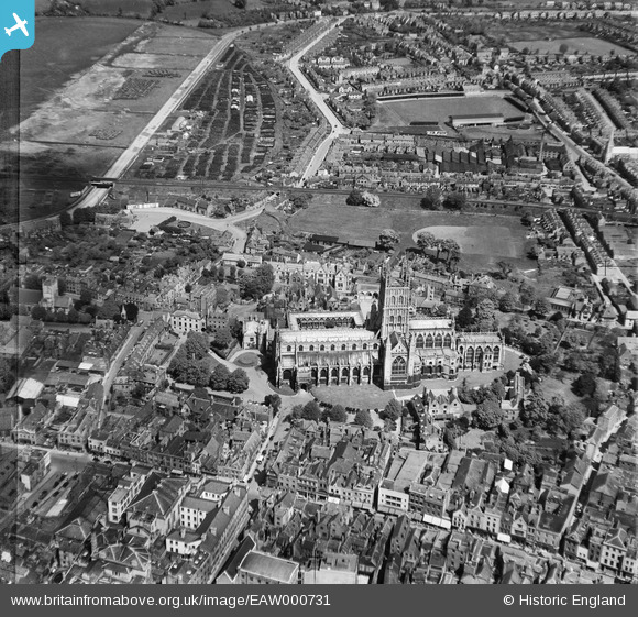
EAW000731 ENGLAND (1946). Holy Trinity Cathedral and environs, Gloucester, 1946
© Copyright OpenStreetMap contributors and licensed by the OpenStreetMap Foundation. 2025. Cartography is licensed as CC BY-SA.
Nearby Images (25)
Details
| Title | [EAW000731] Holy Trinity Cathedral and environs, Gloucester, 1946 |
| Reference | EAW000731 |
| Date | 9-May-1946 |
| Link | |
| Place name | GLOUCESTER |
| Parish | |
| District | |
| Country | ENGLAND |
| Easting / Northing | 383104, 218858 |
| Longitude / Latitude | -2.2454165140905, 51.867602373391 |
| National Grid Reference | SO831189 |
Pins
 Sparky |
Tuesday 26th of September 2017 08:10:00 AM | |
 Sparky |
Tuesday 26th of September 2017 08:09:20 AM | |
 Sparky |
Tuesday 26th of September 2017 08:08:42 AM | |
 Class31 |
Thursday 4th of June 2015 01:46:39 PM | |
Katy Whitaker |
Saturday 5th of October 2013 07:50:33 PM | |
I can't find anything in writing so far but it looks to me like some depot for war surplus tyres. Someone must know what it is. This is within living memory. The Gloucestershire Archives might have some information. |
 Class31 |
Saturday 5th of October 2013 09:36:34 PM |
User Comment Contributions
Memorial to Bishop Hooper and St. Mary's Church looking west 27/09/2013 |
 Class31 |
Monday 30th of September 2013 11:00:20 AM |
Gateway detail 27/09/2013 |
 Class31 |
Monday 30th of September 2013 10:56:47 AM |
Gateway to Cathedral Close looking west 27/09/2013 |
 Class31 |
Monday 30th of September 2013 10:55:38 AM |
War Memorial 27/09/2013 |
 Class31 |
Monday 30th of September 2013 10:48:53 AM |
27/09/2013 |
 Class31 |
Monday 30th of September 2013 10:47:36 AM |


![[EAW000731] Holy Trinity Cathedral and environs, Gloucester, 1946](http://britainfromabove.org.uk/sites/all/libraries/aerofilms-images/public/100x100/EAW/000/EAW000731.jpg)
![[EAW012147] Gloucester Cathedral, Gloucester, 1947](http://britainfromabove.org.uk/sites/all/libraries/aerofilms-images/public/100x100/EAW/012/EAW012147.jpg)
![[EPW024170] Holy Trinity Cathedral and environs, Gloucester, 1928](http://britainfromabove.org.uk/sites/all/libraries/aerofilms-images/public/100x100/EPW/024/EPW024170.jpg)
![[EAW032303] Holy Trinity Cathedral and environs, Gloucester, 1950](http://britainfromabove.org.uk/sites/all/libraries/aerofilms-images/public/100x100/EAW/032/EAW032303.jpg)
![[EAW032305] Holy Trinity Cathedral, Gloucester, 1950](http://britainfromabove.org.uk/sites/all/libraries/aerofilms-images/public/100x100/EAW/032/EAW032305.jpg)
![[EPW041487] The Cathedral Church of St Peter and the Holy Family, Gloucester, 1933](http://britainfromabove.org.uk/sites/all/libraries/aerofilms-images/public/100x100/EPW/041/EPW041487.jpg)
![[EAW032304] Holy Trinity Cathedral, Westgate Street and environs, Gloucester, 1950](http://britainfromabove.org.uk/sites/all/libraries/aerofilms-images/public/100x100/EAW/032/EAW032304.jpg)
![[EAW003567] Gloucester Cathedral, Gloucester, 1947](http://britainfromabove.org.uk/sites/all/libraries/aerofilms-images/public/100x100/EAW/003/EAW003567.jpg)
![[EAW003569] Gloucester Cathedral, Gloucester, 1947](http://britainfromabove.org.uk/sites/all/libraries/aerofilms-images/public/100x100/EAW/003/EAW003569.jpg)
![[EPW024158] Holy Trinity Cathedral and environs, Gloucester, 1928](http://britainfromabove.org.uk/sites/all/libraries/aerofilms-images/public/100x100/EPW/024/EPW024158.jpg)
![[EPW006011] Holy Trinity Cathedral, Gloucester, 1921](http://britainfromabove.org.uk/sites/all/libraries/aerofilms-images/public/100x100/EPW/006/EPW006011.jpg)
![[EAW003568] Gloucester Cathedral, Gloucester, 1947](http://britainfromabove.org.uk/sites/all/libraries/aerofilms-images/public/100x100/EAW/003/EAW003568.jpg)
![[EAW032306] Holy Trinity Cathedral, Gloucester, 1950](http://britainfromabove.org.uk/sites/all/libraries/aerofilms-images/public/100x100/EAW/032/EAW032306.jpg)
![[EPW024152] Holy Trinity Catheral and environs, Gloucester, 1928](http://britainfromabove.org.uk/sites/all/libraries/aerofilms-images/public/100x100/EPW/024/EPW024152.jpg)
![[EPW024155] Holy Trinity Catheral and environs, Gloucester, 1928](http://britainfromabove.org.uk/sites/all/libraries/aerofilms-images/public/100x100/EPW/024/EPW024155.jpg)
![[EPW024163] Holy Trinity Cathedral and the town centre, Gloucester, 1928. This image was marked by Aerofilms Ltd for photo editing.](http://britainfromabove.org.uk/sites/all/libraries/aerofilms-images/public/100x100/EPW/024/EPW024163.jpg)
![[EAW000730] Westgate Street, Holy Trinity Cathedral and environs, Gloucester, 1946](http://britainfromabove.org.uk/sites/all/libraries/aerofilms-images/public/100x100/EAW/000/EAW000730.jpg)
![[EAW003565] Gloucester Cathedral, Gloucester, 1947](http://britainfromabove.org.uk/sites/all/libraries/aerofilms-images/public/100x100/EAW/003/EAW003565.jpg)
![[EAW003566] Gloucester Cathedral, Gloucester, 1947](http://britainfromabove.org.uk/sites/all/libraries/aerofilms-images/public/100x100/EAW/003/EAW003566.jpg)
![[EPW024165] Holy Trinity Cathedral and the town centre, Gloucester, 1928](http://britainfromabove.org.uk/sites/all/libraries/aerofilms-images/public/100x100/EPW/024/EPW024165.jpg)
![[EAW000729] Westgate Street, Holy Trinity Cathedral and environs, Gloucester, 1946](http://britainfromabove.org.uk/sites/all/libraries/aerofilms-images/public/100x100/EAW/000/EAW000729.jpg)
![[EAW000727] Holy Trinity Cathedral and the city, Gloucester, 1946](http://britainfromabove.org.uk/sites/all/libraries/aerofilms-images/public/100x100/EAW/000/EAW000727.jpg)
![[EAW000726] The city, Gloucester, from the south-west, 1946](http://britainfromabove.org.uk/sites/all/libraries/aerofilms-images/public/100x100/EAW/000/EAW000726.jpg)
![[EAW018729] The city, Gloucester, 1948. This image has been produced from a print.](http://britainfromabove.org.uk/sites/all/libraries/aerofilms-images/public/100x100/EAW/018/EAW018729.jpg)
![[EPW024106] The city centre, Gloucester, from the south-west, 1928](http://britainfromabove.org.uk/sites/all/libraries/aerofilms-images/public/100x100/EPW/024/EPW024106.jpg)