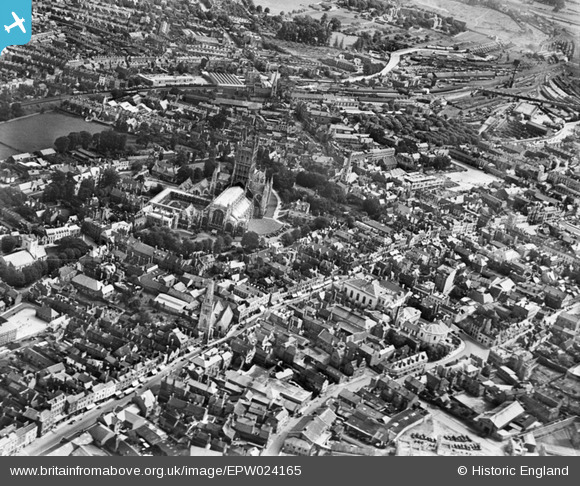
EPW024165 ENGLAND (1928). Holy Trinity Cathedral and the town centre, Gloucester, 1928
© Copyright OpenStreetMap contributors and licensed by the OpenStreetMap Foundation. 2025. Cartography is licensed as CC BY-SA.
Nearby Images (28)
Details
| Title | [EPW024165] Holy Trinity Cathedral and the town centre, Gloucester, 1928 |
| Reference | EPW024165 |
| Date | September-1928 |
| Link | |
| Place name | GLOUCESTER |
| Parish | |
| District | |
| Country | ENGLAND |
| Easting / Northing | 383099, 218726 |
| Longitude / Latitude | -2.2454826775005, 51.866415296183 |
| National Grid Reference | SO831187 |
Pins
 Class31 |
Tuesday 16th of October 2012 12:52:27 PM | |
 Class31 |
Tuesday 16th of October 2012 12:51:19 PM | |
 Class31 |
Tuesday 16th of October 2012 11:36:02 AM | |
 Class31 |
Tuesday 16th of October 2012 11:35:07 AM | |
 Class31 |
Tuesday 16th of October 2012 11:34:19 AM | |
 Class31 |
Tuesday 16th of October 2012 11:33:34 AM | |
 Class31 |
Tuesday 16th of October 2012 11:32:59 AM | |
 Class31 |
Tuesday 16th of October 2012 11:32:32 AM | |
 Class31 |
Tuesday 16th of October 2012 11:32:14 AM | |
 Class31 |
Tuesday 16th of October 2012 11:31:52 AM | |
 Trebor |
Tuesday 28th of August 2012 10:14:37 AM | |
 Trebor |
Tuesday 28th of August 2012 10:13:41 AM | |
 Trebor |
Tuesday 28th of August 2012 10:09:38 AM |
User Comment Contributions
A photograph of Westgate Street may be seen on the Oxford University Archaeology web site as follows http://heirtagger.ox.ac.uk/discuss/discussion/44315/search/keywords:england/page/72 I have taken a photograph of the same scene on 28/10/2014 as follows |
 Class31 |
Thursday 28th of January 2016 07:30:10 PM |
what a differents 84year makes tothe city of Glouester or is it..... |
 les |
Saturday 30th of June 2012 06:11:20 PM |
Shows: * numerous lost frontages to main shopping streets * grand chapel on northgate st, nave tomst Michaels, st aldates * Interesting group of buildings lost to bt blocks on Longsmith st, including beside bull lane * Narrow priory street south of st Nicholas unrecognisable, similarly st marys sq * old asylum on Horton rd isolated in landscaped grounds and fields * significant tree coverage around old cattle Market area east of current kings sq ( cathedral is the 'church of st Peter and the indivisible holy trinity' so title is ok ) |
 Ian Williams |
Saturday 30th of June 2012 12:16:30 AM |
Gloucester Cathedral is St. Peter's , not Holy Trinity, so the title is wrong. |
 Kay Powell |
Friday 29th of June 2012 06:21:44 PM |


![[EPW024165] Holy Trinity Cathedral and the town centre, Gloucester, 1928](http://britainfromabove.org.uk/sites/all/libraries/aerofilms-images/public/100x100/EPW/024/EPW024165.jpg)
![[EAW003566] Gloucester Cathedral, Gloucester, 1947](http://britainfromabove.org.uk/sites/all/libraries/aerofilms-images/public/100x100/EAW/003/EAW003566.jpg)
![[EAW003565] Gloucester Cathedral, Gloucester, 1947](http://britainfromabove.org.uk/sites/all/libraries/aerofilms-images/public/100x100/EAW/003/EAW003565.jpg)
![[EPW024163] Holy Trinity Cathedral and the town centre, Gloucester, 1928. This image was marked by Aerofilms Ltd for photo editing.](http://britainfromabove.org.uk/sites/all/libraries/aerofilms-images/public/100x100/EPW/024/EPW024163.jpg)
![[EAW000730] Westgate Street, Holy Trinity Cathedral and environs, Gloucester, 1946](http://britainfromabove.org.uk/sites/all/libraries/aerofilms-images/public/100x100/EAW/000/EAW000730.jpg)
![[EPW024152] Holy Trinity Catheral and environs, Gloucester, 1928](http://britainfromabove.org.uk/sites/all/libraries/aerofilms-images/public/100x100/EPW/024/EPW024152.jpg)
![[EPW024155] Holy Trinity Catheral and environs, Gloucester, 1928](http://britainfromabove.org.uk/sites/all/libraries/aerofilms-images/public/100x100/EPW/024/EPW024155.jpg)
![[EPW006011] Holy Trinity Cathedral, Gloucester, 1921](http://britainfromabove.org.uk/sites/all/libraries/aerofilms-images/public/100x100/EPW/006/EPW006011.jpg)
![[EPW024158] Holy Trinity Cathedral and environs, Gloucester, 1928](http://britainfromabove.org.uk/sites/all/libraries/aerofilms-images/public/100x100/EPW/024/EPW024158.jpg)
![[EAW003567] Gloucester Cathedral, Gloucester, 1947](http://britainfromabove.org.uk/sites/all/libraries/aerofilms-images/public/100x100/EAW/003/EAW003567.jpg)
![[EAW032304] Holy Trinity Cathedral, Westgate Street and environs, Gloucester, 1950](http://britainfromabove.org.uk/sites/all/libraries/aerofilms-images/public/100x100/EAW/032/EAW032304.jpg)
![[EPW041487] The Cathedral Church of St Peter and the Holy Family, Gloucester, 1933](http://britainfromabove.org.uk/sites/all/libraries/aerofilms-images/public/100x100/EPW/041/EPW041487.jpg)
![[EAW003569] Gloucester Cathedral, Gloucester, 1947](http://britainfromabove.org.uk/sites/all/libraries/aerofilms-images/public/100x100/EAW/003/EAW003569.jpg)
![[EAW000727] Holy Trinity Cathedral and the city, Gloucester, 1946](http://britainfromabove.org.uk/sites/all/libraries/aerofilms-images/public/100x100/EAW/000/EAW000727.jpg)
![[EAW003568] Gloucester Cathedral, Gloucester, 1947](http://britainfromabove.org.uk/sites/all/libraries/aerofilms-images/public/100x100/EAW/003/EAW003568.jpg)
![[EAW032305] Holy Trinity Cathedral, Gloucester, 1950](http://britainfromabove.org.uk/sites/all/libraries/aerofilms-images/public/100x100/EAW/032/EAW032305.jpg)
![[EAW032306] Holy Trinity Cathedral, Gloucester, 1950](http://britainfromabove.org.uk/sites/all/libraries/aerofilms-images/public/100x100/EAW/032/EAW032306.jpg)
![[EAW018729] The city, Gloucester, 1948. This image has been produced from a print.](http://britainfromabove.org.uk/sites/all/libraries/aerofilms-images/public/100x100/EAW/018/EAW018729.jpg)
![[EPW024170] Holy Trinity Cathedral and environs, Gloucester, 1928](http://britainfromabove.org.uk/sites/all/libraries/aerofilms-images/public/100x100/EPW/024/EPW024170.jpg)
![[EAW032303] Holy Trinity Cathedral and environs, Gloucester, 1950](http://britainfromabove.org.uk/sites/all/libraries/aerofilms-images/public/100x100/EAW/032/EAW032303.jpg)
![[EAW000726] The city, Gloucester, from the south-west, 1946](http://britainfromabove.org.uk/sites/all/libraries/aerofilms-images/public/100x100/EAW/000/EAW000726.jpg)
![[EAW000731] Holy Trinity Cathedral and environs, Gloucester, 1946](http://britainfromabove.org.uk/sites/all/libraries/aerofilms-images/public/100x100/EAW/000/EAW000731.jpg)
![[EAW012147] Gloucester Cathedral, Gloucester, 1947](http://britainfromabove.org.uk/sites/all/libraries/aerofilms-images/public/100x100/EAW/012/EAW012147.jpg)
![[EPW024169] Westgate Street, Eastgate Street and the town centre, Gloucester, 1928](http://britainfromabove.org.uk/sites/all/libraries/aerofilms-images/public/100x100/EPW/024/EPW024169.jpg)
![[EAW000729] Westgate Street, Holy Trinity Cathedral and environs, Gloucester, 1946](http://britainfromabove.org.uk/sites/all/libraries/aerofilms-images/public/100x100/EAW/000/EAW000729.jpg)
![[EPW037835] The city centre and docks, Gloucester, 1932](http://britainfromabove.org.uk/sites/all/libraries/aerofilms-images/public/100x100/EPW/037/EPW037835.jpg)
![[EPW024106] The city centre, Gloucester, from the south-west, 1928](http://britainfromabove.org.uk/sites/all/libraries/aerofilms-images/public/100x100/EPW/024/EPW024106.jpg)
![[EAW000728] Northgate Street, Southgate Street and environs, Gloucester, 1946](http://britainfromabove.org.uk/sites/all/libraries/aerofilms-images/public/100x100/EAW/000/EAW000728.jpg)