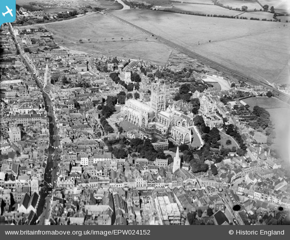
EPW024152 ENGLAND (1928). Holy Trinity Catheral and environs, Gloucester, 1928
© Copyright OpenStreetMap contributors and licensed by the OpenStreetMap Foundation. 2025. Cartography is licensed as CC BY-SA.
Nearby Images (27)
Details
| Title | [EPW024152] Holy Trinity Catheral and environs, Gloucester, 1928 |
| Reference | EPW024152 |
| Date | September-1928 |
| Link | |
| Place name | GLOUCESTER |
| Parish | |
| District | |
| Country | ENGLAND |
| Easting / Northing | 383117, 218757 |
| Longitude / Latitude | -2.2452227505342, 51.866694589082 |
| National Grid Reference | SO831188 |
Pins
 Class31 |
Tuesday 16th of October 2012 02:20:01 PM | |
 Class31 |
Tuesday 16th of October 2012 02:15:22 PM | |
 Class31 |
Tuesday 16th of October 2012 02:14:14 PM | |
 Class31 |
Tuesday 16th of October 2012 02:13:49 PM | |
 Class31 |
Tuesday 16th of October 2012 02:13:26 PM | |
 Class31 |
Tuesday 16th of October 2012 02:12:52 PM | |
 Class31 |
Tuesday 16th of October 2012 02:12:25 PM | |
 gannett |
Saturday 7th of July 2012 02:09:39 PM | |
 gannett |
Saturday 7th of July 2012 02:07:30 PM |
User Comment Contributions
Shows: * st oswalds priory ??? Is that an extant building, constructed around the current medieval ruin? * the oxbode lane, pre widening * st aldates (partial view) * st Michaels c19th nave * pattern of gate street, lane, lane, small street along north gate st from cross to gate site at hare lane * the old westgate bridge; westgate st continuing from cross to bridge, uninterrupted by ring rd |
 Ian Williams |
Saturday 30th of June 2012 10:38:24 AM |


![[EPW024152] Holy Trinity Catheral and environs, Gloucester, 1928](http://britainfromabove.org.uk/sites/all/libraries/aerofilms-images/public/100x100/EPW/024/EPW024152.jpg)
![[EAW000730] Westgate Street, Holy Trinity Cathedral and environs, Gloucester, 1946](http://britainfromabove.org.uk/sites/all/libraries/aerofilms-images/public/100x100/EAW/000/EAW000730.jpg)
![[EPW024155] Holy Trinity Catheral and environs, Gloucester, 1928](http://britainfromabove.org.uk/sites/all/libraries/aerofilms-images/public/100x100/EPW/024/EPW024155.jpg)
![[EAW003565] Gloucester Cathedral, Gloucester, 1947](http://britainfromabove.org.uk/sites/all/libraries/aerofilms-images/public/100x100/EAW/003/EAW003565.jpg)
![[EPW006011] Holy Trinity Cathedral, Gloucester, 1921](http://britainfromabove.org.uk/sites/all/libraries/aerofilms-images/public/100x100/EPW/006/EPW006011.jpg)
![[EAW003569] Gloucester Cathedral, Gloucester, 1947](http://britainfromabove.org.uk/sites/all/libraries/aerofilms-images/public/100x100/EAW/003/EAW003569.jpg)
![[EPW041487] The Cathedral Church of St Peter and the Holy Family, Gloucester, 1933](http://britainfromabove.org.uk/sites/all/libraries/aerofilms-images/public/100x100/EPW/041/EPW041487.jpg)
![[EAW003567] Gloucester Cathedral, Gloucester, 1947](http://britainfromabove.org.uk/sites/all/libraries/aerofilms-images/public/100x100/EAW/003/EAW003567.jpg)
![[EPW024158] Holy Trinity Cathedral and environs, Gloucester, 1928](http://britainfromabove.org.uk/sites/all/libraries/aerofilms-images/public/100x100/EPW/024/EPW024158.jpg)
![[EPW024163] Holy Trinity Cathedral and the town centre, Gloucester, 1928. This image was marked by Aerofilms Ltd for photo editing.](http://britainfromabove.org.uk/sites/all/libraries/aerofilms-images/public/100x100/EPW/024/EPW024163.jpg)
![[EAW003566] Gloucester Cathedral, Gloucester, 1947](http://britainfromabove.org.uk/sites/all/libraries/aerofilms-images/public/100x100/EAW/003/EAW003566.jpg)
![[EAW003568] Gloucester Cathedral, Gloucester, 1947](http://britainfromabove.org.uk/sites/all/libraries/aerofilms-images/public/100x100/EAW/003/EAW003568.jpg)
![[EPW024165] Holy Trinity Cathedral and the town centre, Gloucester, 1928](http://britainfromabove.org.uk/sites/all/libraries/aerofilms-images/public/100x100/EPW/024/EPW024165.jpg)
![[EAW032304] Holy Trinity Cathedral, Westgate Street and environs, Gloucester, 1950](http://britainfromabove.org.uk/sites/all/libraries/aerofilms-images/public/100x100/EAW/032/EAW032304.jpg)
![[EAW032305] Holy Trinity Cathedral, Gloucester, 1950](http://britainfromabove.org.uk/sites/all/libraries/aerofilms-images/public/100x100/EAW/032/EAW032305.jpg)
![[EAW032306] Holy Trinity Cathedral, Gloucester, 1950](http://britainfromabove.org.uk/sites/all/libraries/aerofilms-images/public/100x100/EAW/032/EAW032306.jpg)
![[EPW024170] Holy Trinity Cathedral and environs, Gloucester, 1928](http://britainfromabove.org.uk/sites/all/libraries/aerofilms-images/public/100x100/EPW/024/EPW024170.jpg)
![[EAW032303] Holy Trinity Cathedral and environs, Gloucester, 1950](http://britainfromabove.org.uk/sites/all/libraries/aerofilms-images/public/100x100/EAW/032/EAW032303.jpg)
![[EAW000727] Holy Trinity Cathedral and the city, Gloucester, 1946](http://britainfromabove.org.uk/sites/all/libraries/aerofilms-images/public/100x100/EAW/000/EAW000727.jpg)
![[EAW000731] Holy Trinity Cathedral and environs, Gloucester, 1946](http://britainfromabove.org.uk/sites/all/libraries/aerofilms-images/public/100x100/EAW/000/EAW000731.jpg)
![[EAW018729] The city, Gloucester, 1948. This image has been produced from a print.](http://britainfromabove.org.uk/sites/all/libraries/aerofilms-images/public/100x100/EAW/018/EAW018729.jpg)
![[EAW012147] Gloucester Cathedral, Gloucester, 1947](http://britainfromabove.org.uk/sites/all/libraries/aerofilms-images/public/100x100/EAW/012/EAW012147.jpg)
![[EAW000726] The city, Gloucester, from the south-west, 1946](http://britainfromabove.org.uk/sites/all/libraries/aerofilms-images/public/100x100/EAW/000/EAW000726.jpg)
![[EAW000729] Westgate Street, Holy Trinity Cathedral and environs, Gloucester, 1946](http://britainfromabove.org.uk/sites/all/libraries/aerofilms-images/public/100x100/EAW/000/EAW000729.jpg)
![[EPW024169] Westgate Street, Eastgate Street and the town centre, Gloucester, 1928](http://britainfromabove.org.uk/sites/all/libraries/aerofilms-images/public/100x100/EPW/024/EPW024169.jpg)
![[EPW037835] The city centre and docks, Gloucester, 1932](http://britainfromabove.org.uk/sites/all/libraries/aerofilms-images/public/100x100/EPW/037/EPW037835.jpg)
![[EPW024106] The city centre, Gloucester, from the south-west, 1928](http://britainfromabove.org.uk/sites/all/libraries/aerofilms-images/public/100x100/EPW/024/EPW024106.jpg)