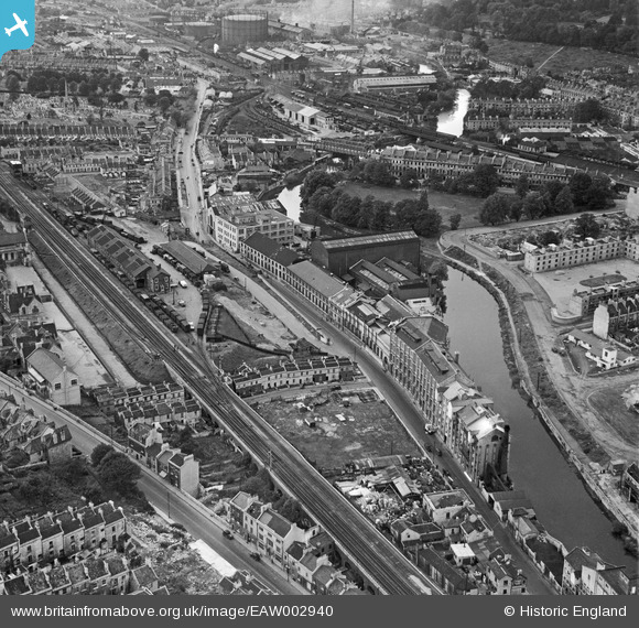
EAW002940 ENGLAND (1946). The Newark Works and Lower Bristol Road, Bath, 1946
© Copyright OpenStreetMap contributors and licensed by the OpenStreetMap Foundation. 2025. Cartography is licensed as CC BY-SA.
Nearby Images (14)
Details
| Title | [EAW002940] The Newark Works and Lower Bristol Road, Bath, 1946 |
| Reference | EAW002940 |
| Date | 2-October-1946 |
| Link | |
| Place name | BATH |
| Parish | |
| District | |
| Country | ENGLAND |
| Easting / Northing | 374625, 164449 |
| Longitude / Latitude | -2.3646300459111, 51.378027993991 |
| National Grid Reference | ST746644 |
Pins
 gerry-r |
Wednesday 18th of September 2024 02:50:13 PM | |
 MB |
Wednesday 31st of August 2016 10:29:20 AM | |
 MB |
Wednesday 31st of August 2016 10:28:39 AM | |
 MB |
Wednesday 31st of August 2016 10:25:54 AM | |
 MB |
Wednesday 31st of August 2016 10:23:09 AM | |
 Class31 |
Thursday 24th of July 2014 03:44:27 PM | |
 Class31 |
Monday 10th of March 2014 10:20:42 AM |


![[EAW002940] The Newark Works and Lower Bristol Road, Bath, 1946](http://britainfromabove.org.uk/sites/all/libraries/aerofilms-images/public/100x100/EAW/002/EAW002940.jpg)
![[EAW002941] The Newark Works and environs, Bath, 1946](http://britainfromabove.org.uk/sites/all/libraries/aerofilms-images/public/100x100/EAW/002/EAW002941.jpg)
![[EAW002945] The Newark Works, Lower Bristol Road and environs, Bath, from the east, 1946](http://britainfromabove.org.uk/sites/all/libraries/aerofilms-images/public/100x100/EAW/002/EAW002945.jpg)
![[EAW002942] The Newark Works and the River Avon, Bath, 1946](http://britainfromabove.org.uk/sites/all/libraries/aerofilms-images/public/100x100/EAW/002/EAW002942.jpg)
![[EAW002939] The Newark Works and the River Avon, Bath, 1946](http://britainfromabove.org.uk/sites/all/libraries/aerofilms-images/public/100x100/EAW/002/EAW002939.jpg)
![[EPW001944] General view over Kingsmead, Bath, 1920](http://britainfromabove.org.uk/sites/all/libraries/aerofilms-images/public/100x100/EPW/001/EPW001944.jpg)
![[EAW002944] The Newark Works, Lower Bristol Road and environs, Bath, from the south-east, 1946](http://britainfromabove.org.uk/sites/all/libraries/aerofilms-images/public/100x100/EAW/002/EAW002944.jpg)
![[EAW023889] The Newark Works, River Avon and environs, Bath, from the south-east, 1949. This image has been produced from a print marked by Aerofilms Ltd for photo editing.](http://britainfromabove.org.uk/sites/all/libraries/aerofilms-images/public/100x100/EAW/023/EAW023889.jpg)
![[EAW026457] The city centre, Bath, from the west, 1949](http://britainfromabove.org.uk/sites/all/libraries/aerofilms-images/public/100x100/EAW/026/EAW026457.jpg)
![[EAW026458] The city centre, Bath, from the south, 1949](http://britainfromabove.org.uk/sites/all/libraries/aerofilms-images/public/100x100/EAW/026/EAW026458.jpg)
![[EAW002943] The Newark Works and the River Avon, Bath, from the west, 1946](http://britainfromabove.org.uk/sites/all/libraries/aerofilms-images/public/100x100/EAW/002/EAW002943.jpg)
![[EAW023886] The Newark Works, River Avon and environs, Bath, from the south-east, 1949. This image has been produced from a print marked by Aerofilms Ltd for photo editing.](http://britainfromabove.org.uk/sites/all/libraries/aerofilms-images/public/100x100/EAW/023/EAW023886.jpg)
![[EAW023888] The Newark Works, River Avon and environs, Bath, from the south-east, 1949. This image has been produced from a print marked by Aerofilms Ltd for photo editing.](http://britainfromabove.org.uk/sites/all/libraries/aerofilms-images/public/100x100/EAW/023/EAW023888.jpg)
![[EPR000131] Upper Oldfield Park and environs, Bath, 1934](http://britainfromabove.org.uk/sites/all/libraries/aerofilms-images/public/100x100/EPR/000/EPR000131.jpg)