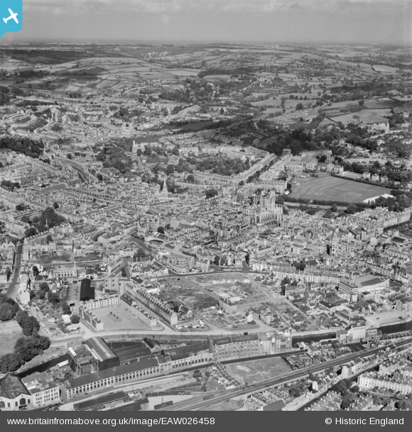
EAW026458 ENGLAND (1949). The city centre, Bath, from the south, 1949
© Copyright OpenStreetMap contributors and licensed by the OpenStreetMap Foundation. 2025. Cartography is licensed as CC BY-SA.
Nearby Images (17)
Details
| Title | [EAW026458] The city centre, Bath, from the south, 1949 |
| Reference | EAW026458 |
| Date | 8-September-1949 |
| Link | |
| Place name | BATH |
| Parish | |
| District | |
| Country | ENGLAND |
| Easting / Northing | 374794, 164563 |
| Longitude / Latitude | -2.3622097170645, 51.37906067174 |
| National Grid Reference | ST748646 |
Pins
 Graham Yaxley |
Saturday 24th of January 2015 05:08:50 PM | |
 Graham Yaxley |
Saturday 24th of January 2015 05:08:00 PM | |
 Graham Yaxley |
Saturday 24th of January 2015 05:07:11 PM | |
 Class31 |
Wednesday 16th of July 2014 08:09:58 AM | |
 Class31 |
Wednesday 16th of July 2014 08:08:17 AM | |
 Class31 |
Wednesday 16th of July 2014 08:07:34 AM | |
 Class31 |
Wednesday 16th of July 2014 08:03:21 AM |
User Comment Contributions
River Avon, Bath, 15/07/2014 |
 Class31 |
Wednesday 16th of July 2014 08:06:20 AM |
Factories & Warehousing alongside the River Avon, Bath, 15/07/2014 |
 Class31 |
Wednesday 16th of July 2014 08:05:35 AM |
Warehouses alongside the River Avon, Bath, 15/07/2014 |
 Class31 |
Wednesday 16th of July 2014 08:04:45 AM |
Warehouses alongside the River Avon, Bath, 15/07/2014 |
 Class31 |
Wednesday 16th of July 2014 08:03:54 AM |


![[EAW026458] The city centre, Bath, from the south, 1949](http://britainfromabove.org.uk/sites/all/libraries/aerofilms-images/public/100x100/EAW/026/EAW026458.jpg)
![[EAW026457] The city centre, Bath, from the west, 1949](http://britainfromabove.org.uk/sites/all/libraries/aerofilms-images/public/100x100/EAW/026/EAW026457.jpg)
![[EPR000130] Broad Quay and the city centre, Bath, 1934](http://britainfromabove.org.uk/sites/all/libraries/aerofilms-images/public/100x100/EPR/000/EPR000130.jpg)
![[EPW001944] General view over Kingsmead, Bath, 1920](http://britainfromabove.org.uk/sites/all/libraries/aerofilms-images/public/100x100/EPW/001/EPW001944.jpg)
![[EPW001169] View over central Bath from Alexandra Park, Bath, 1920](http://britainfromabove.org.uk/sites/all/libraries/aerofilms-images/public/100x100/EPW/001/EPW001169.jpg)
![[EAW002945] The Newark Works, Lower Bristol Road and environs, Bath, from the east, 1946](http://britainfromabove.org.uk/sites/all/libraries/aerofilms-images/public/100x100/EAW/002/EAW002945.jpg)
![[EAW023888] The Newark Works, River Avon and environs, Bath, from the south-east, 1949. This image has been produced from a print marked by Aerofilms Ltd for photo editing.](http://britainfromabove.org.uk/sites/all/libraries/aerofilms-images/public/100x100/EAW/023/EAW023888.jpg)
![[EAW026456] The city centre, Bath, from the west, 1949](http://britainfromabove.org.uk/sites/all/libraries/aerofilms-images/public/100x100/EAW/026/EAW026456.jpg)
![[EPW033156] The city, Bath, 1930](http://britainfromabove.org.uk/sites/all/libraries/aerofilms-images/public/100x100/EPW/033/EPW033156.jpg)
![[EAW023886] The Newark Works, River Avon and environs, Bath, from the south-east, 1949. This image has been produced from a print marked by Aerofilms Ltd for photo editing.](http://britainfromabove.org.uk/sites/all/libraries/aerofilms-images/public/100x100/EAW/023/EAW023886.jpg)
![[EAW002940] The Newark Works and Lower Bristol Road, Bath, 1946](http://britainfromabove.org.uk/sites/all/libraries/aerofilms-images/public/100x100/EAW/002/EAW002940.jpg)
![[EAW023889] The Newark Works, River Avon and environs, Bath, from the south-east, 1949. This image has been produced from a print marked by Aerofilms Ltd for photo editing.](http://britainfromabove.org.uk/sites/all/libraries/aerofilms-images/public/100x100/EAW/023/EAW023889.jpg)
![[EAW023887] The Forum, Newark Works, River Avon and environs, Bath, from the east, 1949. This image has been produced from a print marked by Aerofilms Ltd for photo editing.](http://britainfromabove.org.uk/sites/all/libraries/aerofilms-images/public/100x100/EAW/023/EAW023887.jpg)
![[EAW002944] The Newark Works, Lower Bristol Road and environs, Bath, from the south-east, 1946](http://britainfromabove.org.uk/sites/all/libraries/aerofilms-images/public/100x100/EAW/002/EAW002944.jpg)
![[EAW002941] The Newark Works and environs, Bath, 1946](http://britainfromabove.org.uk/sites/all/libraries/aerofilms-images/public/100x100/EAW/002/EAW002941.jpg)
![[EAW002942] The Newark Works and the River Avon, Bath, 1946](http://britainfromabove.org.uk/sites/all/libraries/aerofilms-images/public/100x100/EAW/002/EAW002942.jpg)
![[EAW026448] The city centre, Bath, from the south, 1949](http://britainfromabove.org.uk/sites/all/libraries/aerofilms-images/public/100x100/EAW/026/EAW026448.jpg)