
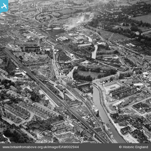
EAW002944 ENGLAND (1946). The Newark Works, Lower Bristol Road and environs, Bath, from the south-east, 1946
© Copyright OpenStreetMap contributors and licensed by the OpenStreetMap Foundation. 2025. Cartography is licensed as CC BY-SA.
Nearby Images (15)
EAW002944

EAW023889

EPW001944

EAW023886

EAW002945

EAW002940

EAW002941

EAW023888

EAW026457

EAW026458

EAW002942

EAW023887

EAW002939

EPW001169

EPR000130

Details
| Title | [EAW002944] The Newark Works, Lower Bristol Road and environs, Bath, from the south-east, 1946 |
| Reference | EAW002944 |
| Date | 2-October-1946 |
| Link | |
| Place name | BATH |
| Parish | |
| District | |
| Country | ENGLAND |
| Easting / Northing | 374728, 164356 |
| Longitude / Latitude | -2.3631433858622, 51.377196286143 |
| National Grid Reference | ST747644 |
Pins
 John Wass |
Saturday 8th of October 2016 08:30:51 PM | |
H Campbell |
Tuesday 10th of February 2015 07:31:02 PM | |
H Campbell |
Tuesday 10th of February 2015 07:21:40 PM | |
H Campbell |
Tuesday 10th of February 2015 07:19:57 PM | |
H Campbell |
Tuesday 10th of February 2015 07:17:37 PM | |
H Campbell |
Tuesday 10th of February 2015 07:13:45 PM | |
H Campbell |
Friday 10th of January 2014 06:12:35 PM | |
H Campbell |
Friday 10th of January 2014 05:37:39 PM | |
H Campbell |
Friday 10th of January 2014 05:16:08 PM | |
H Campbell |
Friday 10th of January 2014 05:00:56 PM | |
Bath Green Park Station was previously known as Bath Queen Square and not as Bath Queen Park. |
 Class31 |
Wednesday 28th of May 2014 08:01:43 AM |
H Campbell |
Friday 10th of January 2014 04:55:01 PM | |
H Campbell |
Friday 10th of January 2014 04:51:24 PM |
User Comment Contributions
 The train shed at Bath Green Park Station 9/3/2014 |
Class31 |
Monday 10th of March 2014 10:36:12 AM |
 This photo shows the aftermath of the Bath Blitz of 25/26 April 1942 on Bath with a number of bomb sites in view. We also see the Bath Midland railway station which is a favourite with railway enthusiasts. We can see how the railway was still important for freight traffic at that time. We can see the Bath gas works and we can see the smoke and steam being given off. Personally seeing the photo I can recall the taste of the fumes which pervaded the air in the vicinity. The smells have gone but some of the gas holders remain today. There are also examples of Georgian architecture to be seen. The area has changed considerably today. |
Class31 |
Wednesday 16th of October 2013 02:12:57 PM |
My mother grew up in Bath and talks of the windows being blown out in the Blitz and having to get water from the local 'pit'. The water was then 'supposed' to be boiled before use. (pit = park - not sure of it's name) |
Alison Cutforth |
Thursday 3rd of October 2013 10:39:09 AM |
There was a play area near Monksdale Road, Bath which was known as the pit. It has a stream running through it and is still there today. I have seen it named Moorfields Play Area and also Sand Pits Play Area. |
Class31 |
Wednesday 16th of October 2013 02:12:57 PM |
This photograph is useful in showing some of the devastated areas of Bath following the Baedeker Raids of 25/26 April 1942. As an example I could not believe my eyes when I saw the complete destruction of a little street which I remember personally from the 1950's. Victoria Road must have been completely rebuilt. |
Class31 |
Wednesday 28th of August 2013 10:47:20 AM |
What a resource for railway modellers! This photo will be of enormous interest to most railway enthusiasts as it shows the goods yards, engine sheds and Bath Midland Station just before nationalisation. |
Class31 |
Wednesday 28th of August 2013 10:34:16 AM |