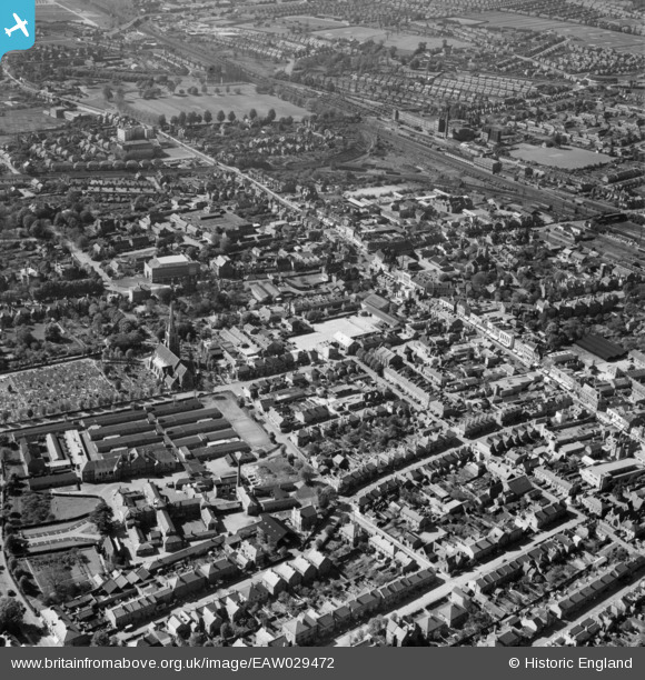
EAW029472 ENGLAND (1950). The High Street, Church Street and the town, Slough, 1950
© Copyright OpenStreetMap contributors and licensed by the OpenStreetMap Foundation. 2025. Cartography is licensed as CC BY-SA.
Nearby Images (17)
Details
| Title | [EAW029472] The High Street, Church Street and the town, Slough, 1950 |
| Reference | EAW029472 |
| Date | 12-May-1950 |
| Link | |
| Place name | SLOUGH |
| Parish | |
| District | |
| Country | ENGLAND |
| Easting / Northing | 497636, 179739 |
| Longitude / Latitude | -0.59299700634982, 51.507653524615 |
| National Grid Reference | SU976797 |
Pins
 Tony S |
Monday 1st of September 2014 04:27:00 PM | |
 Tony S |
Monday 1st of September 2014 04:25:50 PM | |
 Tony S |
Monday 1st of September 2014 04:24:48 PM | |
 Tony S |
Monday 1st of September 2014 04:24:09 PM | |
 Tony S |
Monday 1st of September 2014 04:23:19 PM | |
 Tony S |
Monday 1st of September 2014 04:22:14 PM | |
 Tony S |
Monday 1st of September 2014 04:21:22 PM | |
 Tony S |
Monday 1st of September 2014 04:20:29 PM | |
 Tony S |
Monday 1st of September 2014 04:19:51 PM | |
 Tony S |
Monday 1st of September 2014 04:19:16 PM | |
 payitforwardeddie |
Sunday 23rd of February 2014 04:42:18 PM | |
 dave43 |
Wednesday 19th of February 2014 08:54:15 PM | |
 dave43 |
Wednesday 19th of February 2014 08:53:44 PM |


![[EAW029472] The High Street, Church Street and the town, Slough, 1950](http://britainfromabove.org.uk/sites/all/libraries/aerofilms-images/public/100x100/EAW/029/EAW029472.jpg)
![[EPW012477] The High Street, Bath Road and environs, Slough, 1925. This image has been produced from a copy-negative.](http://britainfromabove.org.uk/sites/all/libraries/aerofilms-images/public/100x100/EPW/012/EPW012477.jpg)
![[EPW056580] The Market Hall and the town centre, Slough, 1938](http://britainfromabove.org.uk/sites/all/libraries/aerofilms-images/public/100x100/EPW/056/EPW056580.jpg)
![[EPR000475] St Mary's Church, Slough, 1935](http://britainfromabove.org.uk/sites/all/libraries/aerofilms-images/public/100x100/EPR/000/EPR000475.jpg)
![[EAW030167] The town, Slough, from the east, 1950](http://britainfromabove.org.uk/sites/all/libraries/aerofilms-images/public/100x100/EAW/030/EAW030167.jpg)
![[EPW061201] The junction of High Street and Church Street and environs, Slough, 1939](http://britainfromabove.org.uk/sites/all/libraries/aerofilms-images/public/100x100/EPW/061/EPW061201.jpg)
![[EPW061199] The High Street and environs, Slough, 1939. This image has been produced from a copy-negative.](http://britainfromabove.org.uk/sites/all/libraries/aerofilms-images/public/100x100/EPW/061/EPW061199.jpg)
![[EPW056578] Bath Road and the town centre, Slough, 1938](http://britainfromabove.org.uk/sites/all/libraries/aerofilms-images/public/100x100/EPW/056/EPW056578.jpg)
![[EPW056576] St Mary's Church, Windsor Road and the town, Slough, 1938](http://britainfromabove.org.uk/sites/all/libraries/aerofilms-images/public/100x100/EPW/056/EPW056576.jpg)
![[EPW061091] The Prudential Buildings at Crown Corner and the surrounding town, Slough, 1939](http://britainfromabove.org.uk/sites/all/libraries/aerofilms-images/public/100x100/EPW/061/EPW061091.jpg)
![[EPR000464] The junction of the Hight Street, William Street and Windsor Road, Slough, 1935](http://britainfromabove.org.uk/sites/all/libraries/aerofilms-images/public/100x100/EPR/000/EPR000464.jpg)
![[EPW056577] The High Street and the town centre, Slough, 1938](http://britainfromabove.org.uk/sites/all/libraries/aerofilms-images/public/100x100/EPW/056/EPW056577.jpg)
![[EPW061200] The town centre, Slough, 1939. This image has been produced from a damaged negative.](http://britainfromabove.org.uk/sites/all/libraries/aerofilms-images/public/100x100/EPW/061/EPW061200.jpg)
![[EPW012476A] St Mary's Church and environs, Slough, 1925. This image has been produced from a copy-negative.](http://britainfromabove.org.uk/sites/all/libraries/aerofilms-images/public/100x100/EPW/012/EPW012476A.jpg)
![[EPW012475] The Old Rectory, Bath Road and environs, Slough, 1925. This image has been produced from a copy-negative.](http://britainfromabove.org.uk/sites/all/libraries/aerofilms-images/public/100x100/EPW/012/EPW012475.jpg)
![[EPW012476] St Mary's Church, Windsor Road and environs, Slough, 1925. This image has been produced from a copy-negative.](http://britainfromabove.org.uk/sites/all/libraries/aerofilms-images/public/100x100/EPW/012/EPW012476.jpg)
![[EPW056579] The town centre, Slough, 1938](http://britainfromabove.org.uk/sites/all/libraries/aerofilms-images/public/100x100/EPW/056/EPW056579.jpg)