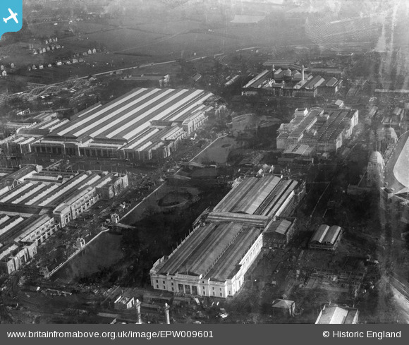
EPW009601 ENGLAND (1923). The British Empire Exhibition site, Wembley Park, 1923
© Copyright OpenStreetMap contributors and licensed by the OpenStreetMap Foundation. 2025. Cartography is licensed as CC BY-SA.
Nearby Images (48)
Details
| Title | [EPW009601] The British Empire Exhibition site, Wembley Park, 1923 |
| Reference | EPW009601 |
| Date | 1923 |
| Link | |
| Place name | WEMBLEY PARK |
| Parish | |
| District | |
| Country | ENGLAND |
| Easting / Northing | 519382, 185773 |
| Longitude / Latitude | -0.2777141356242, 51.557713197192 |
| National Grid Reference | TQ194858 |
Pins
Be the first to add a comment to this image!


![[EPW009601] The British Empire Exhibition site, Wembley Park, 1923](http://britainfromabove.org.uk/sites/all/libraries/aerofilms-images/public/100x100/EPW/009/EPW009601.jpg)
![[EPW010842] The British Empire Exhibition, Wembley Park, 1924](http://britainfromabove.org.uk/sites/all/libraries/aerofilms-images/public/100x100/EPW/010/EPW010842.jpg)
![[EPW040769] The Palace of Industry and the Pleasure Pool, Wembley Park, 1932](http://britainfromabove.org.uk/sites/all/libraries/aerofilms-images/public/100x100/EPW/040/EPW040769.jpg)
![[EPW040768] The north-east corner of Wembley Stadium and the Palace of Industry, Wembley Park, 1932](http://britainfromabove.org.uk/sites/all/libraries/aerofilms-images/public/100x100/EPW/040/EPW040768.jpg)
![[EAW018316] Part of the Empire Stadium, Olympic Way and environs, Wembley Park, 1948. This image has been produced from a print.](http://britainfromabove.org.uk/sites/all/libraries/aerofilms-images/public/100x100/EAW/018/EAW018316.jpg)
![[EPW009806] The British Empire Exhibition, Wembley Park, 1924](http://britainfromabove.org.uk/sites/all/libraries/aerofilms-images/public/100x100/EPW/009/EPW009806.jpg)
![[EPW010736] The British Empire Exhibition, Wembley Park, 1924](http://britainfromabove.org.uk/sites/all/libraries/aerofilms-images/public/100x100/EPW/010/EPW010736.jpg)
![[EPW012752] The British Empire Exhibition, Wembley Park, 1925](http://britainfromabove.org.uk/sites/all/libraries/aerofilms-images/public/100x100/EPW/012/EPW012752.jpg)
![[EPW010848] The British Empire Exhibition, Wembley Park, 1924. This image has been produced from a damaged print.](http://britainfromabove.org.uk/sites/all/libraries/aerofilms-images/public/100x100/EPW/010/EPW010848.jpg)
![[EPW009540] The Palace of Engineering, Palace of Industry and Australia Pavilion under construction, Wembley Park, 1923. This image has been produced from a copy-negative.](http://britainfromabove.org.uk/sites/all/libraries/aerofilms-images/public/100x100/EPW/009/EPW009540.jpg)
![[EPW010726] The British Empire Exhibition, Wembley Park, 1924. This image has been produced from a copy-negative.](http://britainfromabove.org.uk/sites/all/libraries/aerofilms-images/public/100x100/EPW/010/EPW010726.jpg)
![[EAW018315] Part of the Empire Stadium, Olympic Way and environs, Wembley Park, from the south, 1948. This image has been produced from a print.](http://britainfromabove.org.uk/sites/all/libraries/aerofilms-images/public/100x100/EAW/018/EAW018315.jpg)
![[EPW040770] The north-east corner of Wembley Stadium and the Palace of Industry, Wembley Park, 1932. This image has been produced from a damaged negative.](http://britainfromabove.org.uk/sites/all/libraries/aerofilms-images/public/100x100/EPW/040/EPW040770.jpg)
![[EPW009546] The Canada and Australia Pavilions of the British Empire Exhibition under construction, Wembley Park, 1923](http://britainfromabove.org.uk/sites/all/libraries/aerofilms-images/public/100x100/EPW/009/EPW009546.jpg)
![[EPW010735] The British Empire Exhibition, Wembley Park, 1924](http://britainfromabove.org.uk/sites/all/libraries/aerofilms-images/public/100x100/EPW/010/EPW010735.jpg)
![[EPW008242] The Palace of Industry and Palace of Engineering under construction, Wembley Park, 1923. This image has been produced from a copy-negative.](http://britainfromabove.org.uk/sites/all/libraries/aerofilms-images/public/100x100/EPW/008/EPW008242.jpg)
![[EPW020861] The Empire Stadium and car parking for FA Cup Final Day, Wembley Park, from the north, 1928](http://britainfromabove.org.uk/sites/all/libraries/aerofilms-images/public/100x100/EPW/020/EPW020861.jpg)
![[EPW011385] Wembley Park, the British Empire Exhibition, 1924. This image has been produced from a copy-negative.](http://britainfromabove.org.uk/sites/all/libraries/aerofilms-images/public/100x100/EPW/011/EPW011385.jpg)
![[EPW009602] The British Empire Exhibition site, Wembley Park, 1923](http://britainfromabove.org.uk/sites/all/libraries/aerofilms-images/public/100x100/EPW/009/EPW009602.jpg)
![[EPW008279] The British Empire Exhibition Stadium (Wembley Stadium) and site under construction, Wembley Park, 1923. This image has been produced from a copy-negative.](http://britainfromabove.org.uk/sites/all/libraries/aerofilms-images/public/100x100/EPW/008/EPW008279.jpg)
![[EPW009232] The British Empire Exhibition site under construction, Wembley Park, 1923. This image has been produced from a copy negative.](http://britainfromabove.org.uk/sites/all/libraries/aerofilms-images/public/100x100/EPW/009/EPW009232.jpg)
![[EPW009670] The British Empire Exhibition site, Wembley Park, 1923](http://britainfromabove.org.uk/sites/all/libraries/aerofilms-images/public/100x100/EPW/009/EPW009670.jpg)
![[EPW045706] The Empire Swimming Pool and Sports Arena, Wembley Stadium and environs, Wembley Park, 1934. This image has been produced from a damaged negative.](http://britainfromabove.org.uk/sites/all/libraries/aerofilms-images/public/100x100/EPW/045/EPW045706.jpg)
![[EPW008076] The British Empire Exhibition Stadium (Wembley Stadium) under construction, Wembley Park, from the north-west, 1922. This image has been produced from a copy-negative.](http://britainfromabove.org.uk/sites/all/libraries/aerofilms-images/public/100x100/EPW/008/EPW008076.jpg)
![[EPW017629] Wembley Park, The FA Cup Final between Cardiff City and Arsenal, 1927](http://britainfromabove.org.uk/sites/all/libraries/aerofilms-images/public/100x100/EPW/017/EPW017629.jpg)
![[EAW048874] Wembley Stadium, Wembley Park, 1953](http://britainfromabove.org.uk/sites/all/libraries/aerofilms-images/public/100x100/EAW/048/EAW048874.jpg)
![[EPW007831] The Empire Stadium under construction, Wembley Park, 1922. This image has been produced from a copy-negative.](http://britainfromabove.org.uk/sites/all/libraries/aerofilms-images/public/100x100/EPW/007/EPW007831.jpg)
![[EAW018317] The Empire Pool, Wembley Park, 1948. This image has been produced from a print.](http://britainfromabove.org.uk/sites/all/libraries/aerofilms-images/public/100x100/EAW/018/EAW018317.jpg)
![[EPW035050] Wembley Park, Wembley Stadium and environs before the start of the Cup Final between West Bromwich Albion and Birmingham, 1931](http://britainfromabove.org.uk/sites/all/libraries/aerofilms-images/public/100x100/EPW/035/EPW035050.jpg)
![[EPW046239] The Empire Swimming Pool and Sports Arena and Wembley Stadium, Wembley Park, 1934](http://britainfromabove.org.uk/sites/all/libraries/aerofilms-images/public/100x100/EPW/046/EPW046239.jpg)
![[EPW017623] Wembley Park and Stadium, Wembley, 1927](http://britainfromabove.org.uk/sites/all/libraries/aerofilms-images/public/100x100/EPW/017/EPW017623.jpg)
![[EPW010846] The British Empire Exhibition, Wembley Park, 1924](http://britainfromabove.org.uk/sites/all/libraries/aerofilms-images/public/100x100/EPW/010/EPW010846.jpg)
![[EAW048875] Wembley Stadium and the Palace of Industry, Wembley Park, 1953](http://britainfromabove.org.uk/sites/all/libraries/aerofilms-images/public/100x100/EAW/048/EAW048875.jpg)
![[EPW009807] The Palace of Industries and Palace of Engineering at the British Empire Exhibition, Wembley Park, 1924](http://britainfromabove.org.uk/sites/all/libraries/aerofilms-images/public/100x100/EPW/009/EPW009807.jpg)
![[EAW048880] Wembley Stadium and the Palace of Engineering, Wembley Park, 1953](http://britainfromabove.org.uk/sites/all/libraries/aerofilms-images/public/100x100/EAW/048/EAW048880.jpg)
![[EPW034580] The Empire Stadium, Wembley Park, 1930](http://britainfromabove.org.uk/sites/all/libraries/aerofilms-images/public/100x100/EPW/034/EPW034580.jpg)
![[EPW010737] The British Empire Exhibition, Wembley Park, 1924](http://britainfromabove.org.uk/sites/all/libraries/aerofilms-images/public/100x100/EPW/010/EPW010737.jpg)
![[EAW048879] Wembley Stadium and the Palace of Industry, Wembley Park, 1953](http://britainfromabove.org.uk/sites/all/libraries/aerofilms-images/public/100x100/EAW/048/EAW048879.jpg)
![[EPW009547] The Palace of Industries and pavilions of the British Empire Exhibition under construction, Wembley Park, 1923](http://britainfromabove.org.uk/sites/all/libraries/aerofilms-images/public/100x100/EPW/009/EPW009547.jpg)
![[EAW038566] Wembley Park, the Speedway semi-final of the London Cup (Wembley vs New Cross) at Wembley Stadium, 1951. This image has been produced from a print.](http://britainfromabove.org.uk/sites/all/libraries/aerofilms-images/public/100x100/EAW/038/EAW038566.jpg)
![[EAW017619] Wembley Park, crowds gathering at the Empire Stadium for the opening ceremony of the 1948 London Olympics, 1948. This image has been produced from a print.](http://britainfromabove.org.uk/sites/all/libraries/aerofilms-images/public/100x100/EAW/017/EAW017619.jpg)
![[EAW017618] Wembley Park, crowds gathering at the Empire Stadium for the opening ceremony of the 1948 London Olympics, 1948. This image has been produced from a print.](http://britainfromabove.org.uk/sites/all/libraries/aerofilms-images/public/100x100/EAW/017/EAW017618.jpg)
![[EPW010845] The British Empire Exhibition, Wembley Park, 1924](http://britainfromabove.org.uk/sites/all/libraries/aerofilms-images/public/100x100/EPW/010/EPW010845.jpg)
![[EPW008721] Construction of the Palace of Engineering and Palace of Industry, Wembley Park, 1923](http://britainfromabove.org.uk/sites/all/libraries/aerofilms-images/public/100x100/EPW/008/EPW008721.jpg)
![[EPW017625] Wembley Park and Stadium, Wembley, 1927](http://britainfromabove.org.uk/sites/all/libraries/aerofilms-images/public/100x100/EPW/017/EPW017625.jpg)
![[EPW010844] The British Empire Exhibition, Wembley Park, 1924](http://britainfromabove.org.uk/sites/all/libraries/aerofilms-images/public/100x100/EPW/010/EPW010844.jpg)
![[EPW017624] Wembley Park and Stadium, Wembley, 1927](http://britainfromabove.org.uk/sites/all/libraries/aerofilms-images/public/100x100/EPW/017/EPW017624.jpg)
![[EPW046914] Wembley Park, car parking at the FA Cup Final between Sheffield Wednesday and West Bromwich Albion, from the west, 1935](http://britainfromabove.org.uk/sites/all/libraries/aerofilms-images/public/100x100/EPW/046/EPW046914.jpg)