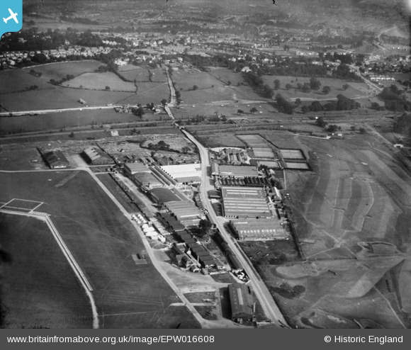
EPW016608 ENGLAND (1926). Factories on the southern side of RAF Hendon, the London Country Club and environs, Hendon, 1926
© Copyright OpenStreetMap contributors and licensed by the OpenStreetMap Foundation. 2025. Cartography is licensed as CC BY-SA.
Nearby Images (27)
Details
| Title | [EPW016608] Factories on the southern side of RAF Hendon, the London Country Club and environs, Hendon, 1926 |
| Reference | EPW016608 |
| Date | 26-August-1926 |
| Link | |
| Place name | HENDON |
| Parish | |
| District | |
| Country | ENGLAND |
| Easting / Northing | 521979, 189859 |
| Longitude / Latitude | -0.23884764393684, 51.593883034229 |
| National Grid Reference | TQ220899 |
Pins
 Brightonboy |
Monday 16th of February 2015 08:31:49 PM | |
 John G. |
Monday 16th of February 2015 07:51:07 PM | |
 John G. |
Monday 16th of February 2015 07:49:58 PM | |
 John G. |
Monday 16th of February 2015 07:48:50 PM | |
 John G. |
Monday 16th of February 2015 07:47:56 PM | |
 John G. |
Monday 16th of February 2015 07:46:04 PM | |
 John G. |
Monday 16th of February 2015 07:45:27 PM |


![[EPW016608] Factories on the southern side of RAF Hendon, the London Country Club and environs, Hendon, 1926](http://britainfromabove.org.uk/sites/all/libraries/aerofilms-images/public/100x100/EPW/016/EPW016608.jpg)
![[EPW002008] The London Country Club, Hendon, 1920](http://britainfromabove.org.uk/sites/all/libraries/aerofilms-images/public/100x100/EPW/002/EPW002008.jpg)
![[EPW002008A] The London Country Club, Hendon, 1920. This image has been produced from a print.](http://britainfromabove.org.uk/sites/all/libraries/aerofilms-images/public/100x100/EPW/002/EPW002008A.jpg)
![[EPW006132] Aerofilms Ltd, Hendon, 1921](http://britainfromabove.org.uk/sites/all/libraries/aerofilms-images/public/100x100/EPW/006/EPW006132.jpg)
![[EPW016611] The London Country Club and factories on the southern side of RAF Hendon, Hendon, 1926](http://britainfromabove.org.uk/sites/all/libraries/aerofilms-images/public/100x100/EPW/016/EPW016611.jpg)
![[EPW000006] Aerodrome and Works, Hendon, 1919](http://britainfromabove.org.uk/sites/all/libraries/aerofilms-images/public/100x100/EPW/000/EPW000006.jpg)
![[EPW000014] London Country Club, Hendon, 1919](http://britainfromabove.org.uk/sites/all/libraries/aerofilms-images/public/100x100/EPW/000/EPW000014.jpg)
![[EPW000001] London Country Club, Hendon, 1919](http://britainfromabove.org.uk/sites/all/libraries/aerofilms-images/public/100x100/EPW/000/EPW000001.jpg)
![[EPW000013] London Country Club, Hendon, 1919](http://britainfromabove.org.uk/sites/all/libraries/aerofilms-images/public/100x100/EPW/000/EPW000013.jpg)
![[EPW000009] London Country Club, Hendon, 1919](http://britainfromabove.org.uk/sites/all/libraries/aerofilms-images/public/100x100/EPW/000/EPW000009.jpg)
![[EPW016610] The London Country Club and factories on the southern side of RAF Hendon, Hendon, 1926](http://britainfromabove.org.uk/sites/all/libraries/aerofilms-images/public/100x100/EPW/016/EPW016610.jpg)
![[EPW002010] The London Country Club, Hendon, 1920](http://britainfromabove.org.uk/sites/all/libraries/aerofilms-images/public/100x100/EPW/002/EPW002010.jpg)
![[EPW009684] The London Country Club and aerodrome buildings, Hendon, 1923](http://britainfromabove.org.uk/sites/all/libraries/aerofilms-images/public/100x100/EPW/009/EPW009684.jpg)
![[EPW002007] The London Country Club, Hendon, 1920](http://britainfromabove.org.uk/sites/all/libraries/aerofilms-images/public/100x100/EPW/002/EPW002007.jpg)
![[EPW000012] London Country Club, Hendon, 1919](http://britainfromabove.org.uk/sites/all/libraries/aerofilms-images/public/100x100/EPW/000/EPW000012.jpg)
![[EPW000010] London Country Club, Hendon, 1919](http://britainfromabove.org.uk/sites/all/libraries/aerofilms-images/public/100x100/EPW/000/EPW000010.jpg)
![[EPW002011] The London Country Club, Hendon, from the north-east, 1920](http://britainfromabove.org.uk/sites/all/libraries/aerofilms-images/public/100x100/EPW/002/EPW002011.jpg)
![[EPW016609] Factories on the southern side of RAF Hendon, Hendon, 1926](http://britainfromabove.org.uk/sites/all/libraries/aerofilms-images/public/100x100/EPW/016/EPW016609.jpg)
![[EPW016606] Factories on the southern side of RAF Hendon and the London Country Club, Hendon, 1926](http://britainfromabove.org.uk/sites/all/libraries/aerofilms-images/public/100x100/EPW/016/EPW016606.jpg)
![[EPW007392] London Country Club, Aerodrome Road and Hendon Aerodrome, Colindale, from the south-east, 1921. This image has been produced from a copy-negative.](http://britainfromabove.org.uk/sites/all/libraries/aerofilms-images/public/100x100/EPW/007/EPW007392.jpg)
![[EPW016605] Factories on the southern side of RAF Hendon, Hendon, 1926](http://britainfromabove.org.uk/sites/all/libraries/aerofilms-images/public/100x100/EPW/016/EPW016605.jpg)
![[EPW016612] The London Country Club and factories on the southern side of RAF Hendon, Hendon, 1926](http://britainfromabove.org.uk/sites/all/libraries/aerofilms-images/public/100x100/EPW/016/EPW016612.jpg)
![[EPW016607] Factories on the southern side of RAF Hendon and the London Country Club, Hendon, 1926](http://britainfromabove.org.uk/sites/all/libraries/aerofilms-images/public/100x100/EPW/016/EPW016607.jpg)
![[EPR000650] Hendon Aerodrome, Colindale, 1935](http://britainfromabove.org.uk/sites/all/libraries/aerofilms-images/public/100x100/EPR/000/EPR000650.jpg)
![[EPW008852] Factories on the southern side of RAF Hendon, Hendon, 1923](http://britainfromabove.org.uk/sites/all/libraries/aerofilms-images/public/100x100/EPW/008/EPW008852.jpg)
![[EPW006859] The London Country Club, Hendon, 1921. This image has been produced from a copy-negative.](http://britainfromabove.org.uk/sites/all/libraries/aerofilms-images/public/100x100/EPW/006/EPW006859.jpg)
![[EPW008760] RAF Pageant, Hendon, from the north, 1923](http://britainfromabove.org.uk/sites/all/libraries/aerofilms-images/public/100x100/EPW/008/EPW008760.jpg)