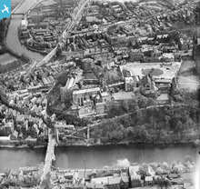
EPW026591 ENGLAND (1929). The Castle and Palace Green overlooking Framwelgate Bridge, Durham, 1929
© Copyright OpenStreetMap contributors and licensed by the OpenStreetMap Foundation. 2024. Cartography is licensed as CC BY-SA.
Nearby Images (23)
Details
| Title | [EPW026591] The Castle and Palace Green overlooking Framwelgate Bridge, Durham, 1929 |
| Reference | EPW026591 |
| Date | May-1929 |
| Link | |
| Place name | DURHAM |
| Parish | |
| District | |
| Country | ENGLAND |
| Easting / Northing | 427313, 542339 |
| Longitude / Latitude | -1.5753535211427, 54.775123950269 |
| National Grid Reference | NZ273423 |
Pins
 Val |
Saturday 26th of November 2016 01:31:16 PM | |
 history group |
Wednesday 16th of April 2014 05:43:39 PM | |
 billandjm |
Friday 18th of January 2013 04:16:04 PM | |
 Class31 |
Tuesday 23rd of October 2012 12:00:20 AM | |
 Class31 |
Monday 22nd of October 2012 11:59:50 PM | |
 anwyn |
Tuesday 26th of June 2012 07:31:24 PM | |
 anwyn |
Tuesday 26th of June 2012 07:28:15 PM | |
 anwyn |
Tuesday 26th of June 2012 07:27:41 PM | |
 anwyn |
Tuesday 26th of June 2012 07:26:29 PM | |
 anwyn |
Tuesday 26th of June 2012 07:22:38 PM |
User Comment Contributions
 An original period photograph entitled "Castle from River" showing Framwellgate Bridge taken June or July 1939 |
 Class31 |
Tuesday 6th of May 2014 02:50:07 PM |
 history group |
Wednesday 16th of April 2014 05:26:56 PM | |
 history group |
Wednesday 16th of April 2014 05:03:41 PM | |
The side of the Castle facing the river is covered with scaffolding and a chute for spoil runs down to the riverside path, in connection with the massive works to underpin the historic building to prevent its slipping into the Wear. The work was partly funded by an international appeal and continued well into the Thirties. |
 jif |
Tuesday 10th of July 2012 12:12:02 PM |


![[EPW026591] The Castle and Palace Green overlooking Framwelgate Bridge, Durham, 1929](http://britainfromabove.org.uk/sites/all/libraries/aerofilms-images/public/100x100/EPW/026/EPW026591.jpg)
![[EPW026650] The Castle and the Cathedral Church of Christ and St Mary the Virgin, Durham, 1929](http://britainfromabove.org.uk/sites/all/libraries/aerofilms-images/public/100x100/EPW/026/EPW026650.jpg)
![[EAW005522] Durham Castle and the city centre, Durham, 1947](http://britainfromabove.org.uk/sites/all/libraries/aerofilms-images/public/100x100/EAW/005/EAW005522.jpg)
![[EAW005523] Durham Cathedral and Castle, Durham, 1947](http://britainfromabove.org.uk/sites/all/libraries/aerofilms-images/public/100x100/EAW/005/EAW005523.jpg)
![[EPW026648] The Castle and Palace Green, Durham, 1929](http://britainfromabove.org.uk/sites/all/libraries/aerofilms-images/public/100x100/EPW/026/EPW026648.jpg)
![[EAW014480] Durham Castle and the Palace Green, Durham, 1948](http://britainfromabove.org.uk/sites/all/libraries/aerofilms-images/public/100x100/EAW/014/EAW014480.jpg)
![[EPW026649] The Castle, Durham, 1929](http://britainfromabove.org.uk/sites/all/libraries/aerofilms-images/public/100x100/EPW/026/EPW026649.jpg)
![[EAW014481] Durham Castle and the Palace Green, Durham, 1948](http://britainfromabove.org.uk/sites/all/libraries/aerofilms-images/public/100x100/EAW/014/EAW014481.jpg)
![[EPW026647] The Castle and the Cathedral Church of Christ and St Mary the Virgin overlooking Framwellgate Bridge, Durham, 1929](http://britainfromabove.org.uk/sites/all/libraries/aerofilms-images/public/100x100/EPW/026/EPW026647.jpg)
![[EAW014482] Durham Castle and Cathedral, Durham, 1948](http://britainfromabove.org.uk/sites/all/libraries/aerofilms-images/public/100x100/EAW/014/EAW014482.jpg)
![[EAW007832] The Castle and Palace Green, Durham, 1947](http://britainfromabove.org.uk/sites/all/libraries/aerofilms-images/public/100x100/EAW/007/EAW007832.jpg)
![[EAW017421] Framwellgate Bridge and Silver Street on the day of the Durham Miners' Gala, Durham, 1948. This image has been produced from a print.](http://britainfromabove.org.uk/sites/all/libraries/aerofilms-images/public/100x100/EAW/017/EAW017421.jpg)
![[EAW007838] The Castle and the Cathedral Church of Christ and St Mary the Virgin, Durham, 1947](http://britainfromabove.org.uk/sites/all/libraries/aerofilms-images/public/100x100/EAW/007/EAW007838.jpg)
![[EAW005520] Durham Cathedral and the peninsula, Durham, 1947](http://britainfromabove.org.uk/sites/all/libraries/aerofilms-images/public/100x100/EAW/005/EAW005520.jpg)
![[EAW005525] Durham Castle and the city centre, Durham, 1947](http://britainfromabove.org.uk/sites/all/libraries/aerofilms-images/public/100x100/EAW/005/EAW005525.jpg)
![[EPW016378] The Cathedral Church of Christ and St Mary the Virgin and the castle, Durham, 1926](http://britainfromabove.org.uk/sites/all/libraries/aerofilms-images/public/100x100/EPW/016/EPW016378.jpg)
![[EAW017412] The Market Place and Saddler Street on the day of the Durham Miners' Gala, Durham, 1948. This image has been produced from a print.](http://britainfromabove.org.uk/sites/all/libraries/aerofilms-images/public/100x100/EAW/017/EAW017412.jpg)
![[EPW016377] The Cathedral Church of Christ and St Mary the Virgin and the castle, Durham, 1926](http://britainfromabove.org.uk/sites/all/libraries/aerofilms-images/public/100x100/EPW/016/EPW016377.jpg)
![[EAW007837] The Cathedral Church of Christ and St Mary the Virgin, Durham, 1947](http://britainfromabove.org.uk/sites/all/libraries/aerofilms-images/public/100x100/EAW/007/EAW007837.jpg)
![[EAW014484] Durham Castle and Cathedral, Durham, 1948](http://britainfromabove.org.uk/sites/all/libraries/aerofilms-images/public/100x100/EAW/014/EAW014484.jpg)
![[EAW017465] Durham Cathedral, Durham, from the west, 1948. This image has been produced from a print.](http://britainfromabove.org.uk/sites/all/libraries/aerofilms-images/public/100x100/EAW/017/EAW017465.jpg)
![[EAW007839] The Castle and the Cathedral Church of Christ and St Mary the Virgin, Durham, 1947](http://britainfromabove.org.uk/sites/all/libraries/aerofilms-images/public/100x100/EAW/007/EAW007839.jpg)
![[EAW005524] Durham Cathedral and Castle, Durham, 1947](http://britainfromabove.org.uk/sites/all/libraries/aerofilms-images/public/100x100/EAW/005/EAW005524.jpg)
