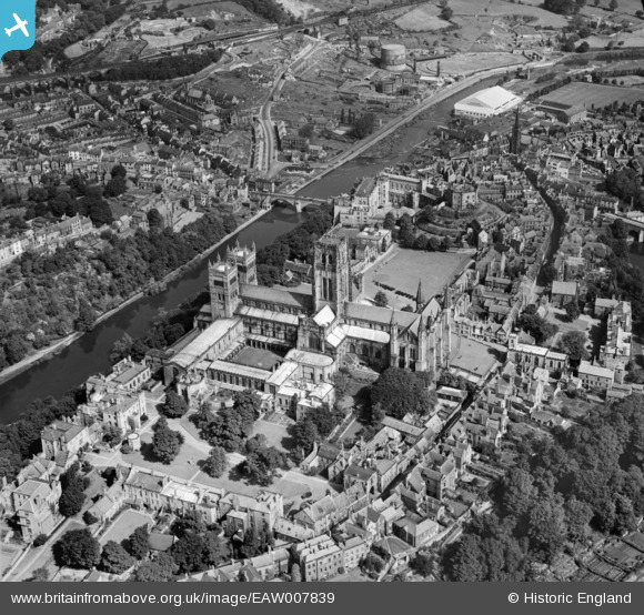
EAW007839 ENGLAND (1947). The Castle and the Cathedral Church of Christ and St Mary the Virgin, Durham, 1947
© Copyright OpenStreetMap contributors and licensed by the OpenStreetMap Foundation. 2025. Cartography is licensed as CC BY-SA.
Nearby Images (24)
Details
| Title | [EAW007839] The Castle and the Cathedral Church of Christ and St Mary the Virgin, Durham, 1947 |
| Reference | EAW007839 |
| Date | 27-June-1947 |
| Link | |
| Place name | DURHAM |
| Parish | |
| District | |
| Country | ENGLAND |
| Easting / Northing | 427356, 542130 |
| Longitude / Latitude | -1.5747047056716, 54.773243261596 |
| National Grid Reference | NZ274421 |
Pins
 Val |
Sunday 5th of February 2017 01:03:32 PM | |
 Val |
Sunday 5th of February 2017 01:01:53 PM | |
 Val |
Sunday 5th of February 2017 01:00:53 PM | |
 Val |
Sunday 5th of February 2017 01:00:01 PM | |
 gBr |
Tuesday 6th of January 2015 09:56:53 PM | |
Originally Durham City FC, from 1937 expanded for dog racing. |
 Brigham |
Thursday 2nd of March 2017 04:18:02 PM |


![[EAW007839] The Castle and the Cathedral Church of Christ and St Mary the Virgin, Durham, 1947](http://britainfromabove.org.uk/sites/all/libraries/aerofilms-images/public/100x100/EAW/007/EAW007839.jpg)
![[EAW014484] Durham Castle and Cathedral, Durham, 1948](http://britainfromabove.org.uk/sites/all/libraries/aerofilms-images/public/100x100/EAW/014/EAW014484.jpg)
![[EAW007837] The Cathedral Church of Christ and St Mary the Virgin, Durham, 1947](http://britainfromabove.org.uk/sites/all/libraries/aerofilms-images/public/100x100/EAW/007/EAW007837.jpg)
![[EPW016377] The Cathedral Church of Christ and St Mary the Virgin and the castle, Durham, 1926](http://britainfromabove.org.uk/sites/all/libraries/aerofilms-images/public/100x100/EPW/016/EPW016377.jpg)
![[EPW016378] The Cathedral Church of Christ and St Mary the Virgin and the castle, Durham, 1926](http://britainfromabove.org.uk/sites/all/libraries/aerofilms-images/public/100x100/EPW/016/EPW016378.jpg)
![[EPW016376] The Cathedral Church of Christ and St Mary the Virgin and the castle, Durham, 1926](http://britainfromabove.org.uk/sites/all/libraries/aerofilms-images/public/100x100/EPW/016/EPW016376.jpg)
![[EAW014485] Durham Cathedral and the peninsula, Durham, 1948](http://britainfromabove.org.uk/sites/all/libraries/aerofilms-images/public/100x100/EAW/014/EAW014485.jpg)
![[EAW017465] Durham Cathedral, Durham, from the west, 1948. This image has been produced from a print.](http://britainfromabove.org.uk/sites/all/libraries/aerofilms-images/public/100x100/EAW/017/EAW017465.jpg)
![[EAW007838] The Castle and the Cathedral Church of Christ and St Mary the Virgin, Durham, 1947](http://britainfromabove.org.uk/sites/all/libraries/aerofilms-images/public/100x100/EAW/007/EAW007838.jpg)
![[EAW005524] Durham Cathedral and Castle, Durham, 1947](http://britainfromabove.org.uk/sites/all/libraries/aerofilms-images/public/100x100/EAW/005/EAW005524.jpg)
![[EAW005521] Prebends Bridge, Durham Cathedral and the peninsula, Durham, 1947](http://britainfromabove.org.uk/sites/all/libraries/aerofilms-images/public/100x100/EAW/005/EAW005521.jpg)
![[EAW014482] Durham Castle and Cathedral, Durham, 1948](http://britainfromabove.org.uk/sites/all/libraries/aerofilms-images/public/100x100/EAW/014/EAW014482.jpg)
![[EAW005520] Durham Cathedral and the peninsula, Durham, 1947](http://britainfromabove.org.uk/sites/all/libraries/aerofilms-images/public/100x100/EAW/005/EAW005520.jpg)
![[EAW014483] Durham Cathedral, Durham, 1948](http://britainfromabove.org.uk/sites/all/libraries/aerofilms-images/public/100x100/EAW/014/EAW014483.jpg)
![[EAW017463] Durham Cathedral and the Peninsula, Durham, 1948. This image has been produced from a print.](http://britainfromabove.org.uk/sites/all/libraries/aerofilms-images/public/100x100/EAW/017/EAW017463.jpg)
![[EAW005523] Durham Cathedral and Castle, Durham, 1947](http://britainfromabove.org.uk/sites/all/libraries/aerofilms-images/public/100x100/EAW/005/EAW005523.jpg)
![[EPW026650] The Castle and the Cathedral Church of Christ and St Mary the Virgin, Durham, 1929](http://britainfromabove.org.uk/sites/all/libraries/aerofilms-images/public/100x100/EPW/026/EPW026650.jpg)
![[EAW014481] Durham Castle and the Palace Green, Durham, 1948](http://britainfromabove.org.uk/sites/all/libraries/aerofilms-images/public/100x100/EAW/014/EAW014481.jpg)
![[EPW026591] The Castle and Palace Green overlooking Framwelgate Bridge, Durham, 1929](http://britainfromabove.org.uk/sites/all/libraries/aerofilms-images/public/100x100/EPW/026/EPW026591.jpg)
![[EAW005522] Durham Castle and the city centre, Durham, 1947](http://britainfromabove.org.uk/sites/all/libraries/aerofilms-images/public/100x100/EAW/005/EAW005522.jpg)
![[EPW026649] The Castle, Durham, 1929](http://britainfromabove.org.uk/sites/all/libraries/aerofilms-images/public/100x100/EPW/026/EPW026649.jpg)
![[EAW007832] The Castle and Palace Green, Durham, 1947](http://britainfromabove.org.uk/sites/all/libraries/aerofilms-images/public/100x100/EAW/007/EAW007832.jpg)
![[EPW026648] The Castle and Palace Green, Durham, 1929](http://britainfromabove.org.uk/sites/all/libraries/aerofilms-images/public/100x100/EPW/026/EPW026648.jpg)
![[EAW014480] Durham Castle and the Palace Green, Durham, 1948](http://britainfromabove.org.uk/sites/all/libraries/aerofilms-images/public/100x100/EAW/014/EAW014480.jpg)