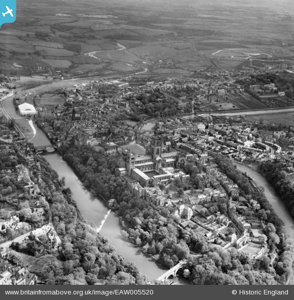
EAW005520 ENGLAND (1947). Durham Cathedral and the peninsula, Durham, 1947
© Copyright OpenStreetMap contributors and licensed by the OpenStreetMap Foundation. 2024. Cartography is licensed as CC BY-SA.
Nearby Images (26)
Details
| Title | [EAW005520] Durham Cathedral and the peninsula, Durham, 1947 |
| Reference | EAW005520 |
| Date | 15-May-1947 |
| Link | |
| Place name | DURHAM |
| Parish | |
| District | |
| Country | ENGLAND |
| Easting / Northing | 427421, 542256 |
| Longitude / Latitude | -1.5736822955973, 54.774372115705 |
| National Grid Reference | NZ274423 |
Pins
 Mike Syer |
Wednesday 14th of February 2024 05:47:06 PM | |
 Mike Syer |
Wednesday 14th of February 2024 05:42:01 PM | |
 Val |
Thursday 4th of October 2018 04:00:38 PM | |
 Val |
Thursday 4th of October 2018 03:56:02 PM | |
 Val |
Thursday 4th of October 2018 03:55:14 PM | |
 Val |
Thursday 4th of October 2018 03:52:56 PM | |
 Val |
Thursday 4th of October 2018 03:52:03 PM | |
 Val |
Thursday 4th of October 2018 03:50:43 PM | |
 richendean |
Tuesday 13th of February 2018 12:30:20 PM | |
 Class31 |
Tuesday 6th of May 2014 02:56:13 PM |
User Comment Contributions
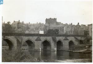
 An original period photograph entitled "Cathedral from Framwellgate Bridge." taken June or July 1939 |
 Class31 |
Tuesday 6th of May 2014 03:04:31 PM |


![[EAW005520] Durham Cathedral and the peninsula, Durham, 1947](http://britainfromabove.org.uk/sites/all/libraries/aerofilms-images/public/100x100/EAW/005/EAW005520.jpg)
![[EAW014481] Durham Castle and the Palace Green, Durham, 1948](http://britainfromabove.org.uk/sites/all/libraries/aerofilms-images/public/100x100/EAW/014/EAW014481.jpg)
![[EAW005523] Durham Cathedral and Castle, Durham, 1947](http://britainfromabove.org.uk/sites/all/libraries/aerofilms-images/public/100x100/EAW/005/EAW005523.jpg)
![[EAW007838] The Castle and the Cathedral Church of Christ and St Mary the Virgin, Durham, 1947](http://britainfromabove.org.uk/sites/all/libraries/aerofilms-images/public/100x100/EAW/007/EAW007838.jpg)
![[EAW014482] Durham Castle and Cathedral, Durham, 1948](http://britainfromabove.org.uk/sites/all/libraries/aerofilms-images/public/100x100/EAW/014/EAW014482.jpg)
![[EAW007832] The Castle and Palace Green, Durham, 1947](http://britainfromabove.org.uk/sites/all/libraries/aerofilms-images/public/100x100/EAW/007/EAW007832.jpg)
![[EPW026650] The Castle and the Cathedral Church of Christ and St Mary the Virgin, Durham, 1929](http://britainfromabove.org.uk/sites/all/libraries/aerofilms-images/public/100x100/EPW/026/EPW026650.jpg)
![[EPW026649] The Castle, Durham, 1929](http://britainfromabove.org.uk/sites/all/libraries/aerofilms-images/public/100x100/EPW/026/EPW026649.jpg)
![[EAW005522] Durham Castle and the city centre, Durham, 1947](http://britainfromabove.org.uk/sites/all/libraries/aerofilms-images/public/100x100/EAW/005/EAW005522.jpg)
![[EAW005524] Durham Cathedral and Castle, Durham, 1947](http://britainfromabove.org.uk/sites/all/libraries/aerofilms-images/public/100x100/EAW/005/EAW005524.jpg)
![[EPW026591] The Castle and Palace Green overlooking Framwelgate Bridge, Durham, 1929](http://britainfromabove.org.uk/sites/all/libraries/aerofilms-images/public/100x100/EPW/026/EPW026591.jpg)
![[EPW026648] The Castle and Palace Green, Durham, 1929](http://britainfromabove.org.uk/sites/all/libraries/aerofilms-images/public/100x100/EPW/026/EPW026648.jpg)
![[EAW007839] The Castle and the Cathedral Church of Christ and St Mary the Virgin, Durham, 1947](http://britainfromabove.org.uk/sites/all/libraries/aerofilms-images/public/100x100/EAW/007/EAW007839.jpg)
![[EAW014484] Durham Castle and Cathedral, Durham, 1948](http://britainfromabove.org.uk/sites/all/libraries/aerofilms-images/public/100x100/EAW/014/EAW014484.jpg)
![[EPW016377] The Cathedral Church of Christ and St Mary the Virgin and the castle, Durham, 1926](http://britainfromabove.org.uk/sites/all/libraries/aerofilms-images/public/100x100/EPW/016/EPW016377.jpg)
![[EAW014480] Durham Castle and the Palace Green, Durham, 1948](http://britainfromabove.org.uk/sites/all/libraries/aerofilms-images/public/100x100/EAW/014/EAW014480.jpg)
![[EAW007837] The Cathedral Church of Christ and St Mary the Virgin, Durham, 1947](http://britainfromabove.org.uk/sites/all/libraries/aerofilms-images/public/100x100/EAW/007/EAW007837.jpg)
![[EPW016378] The Cathedral Church of Christ and St Mary the Virgin and the castle, Durham, 1926](http://britainfromabove.org.uk/sites/all/libraries/aerofilms-images/public/100x100/EPW/016/EPW016378.jpg)
![[EPW026647] The Castle and the Cathedral Church of Christ and St Mary the Virgin overlooking Framwellgate Bridge, Durham, 1929](http://britainfromabove.org.uk/sites/all/libraries/aerofilms-images/public/100x100/EPW/026/EPW026647.jpg)
![[EAW017465] Durham Cathedral, Durham, from the west, 1948. This image has been produced from a print.](http://britainfromabove.org.uk/sites/all/libraries/aerofilms-images/public/100x100/EAW/017/EAW017465.jpg)
![[EPW016376] The Cathedral Church of Christ and St Mary the Virgin and the castle, Durham, 1926](http://britainfromabove.org.uk/sites/all/libraries/aerofilms-images/public/100x100/EPW/016/EPW016376.jpg)
![[EAW014485] Durham Cathedral and the peninsula, Durham, 1948](http://britainfromabove.org.uk/sites/all/libraries/aerofilms-images/public/100x100/EAW/014/EAW014485.jpg)
![[EAW005525] Durham Castle and the city centre, Durham, 1947](http://britainfromabove.org.uk/sites/all/libraries/aerofilms-images/public/100x100/EAW/005/EAW005525.jpg)
![[EAW017421] Framwellgate Bridge and Silver Street on the day of the Durham Miners' Gala, Durham, 1948. This image has been produced from a print.](http://britainfromabove.org.uk/sites/all/libraries/aerofilms-images/public/100x100/EAW/017/EAW017421.jpg)
![[EAW017412] The Market Place and Saddler Street on the day of the Durham Miners' Gala, Durham, 1948. This image has been produced from a print.](http://britainfromabove.org.uk/sites/all/libraries/aerofilms-images/public/100x100/EAW/017/EAW017412.jpg)
![[EAW005521] Prebends Bridge, Durham Cathedral and the peninsula, Durham, 1947](http://britainfromabove.org.uk/sites/all/libraries/aerofilms-images/public/100x100/EAW/005/EAW005521.jpg)
