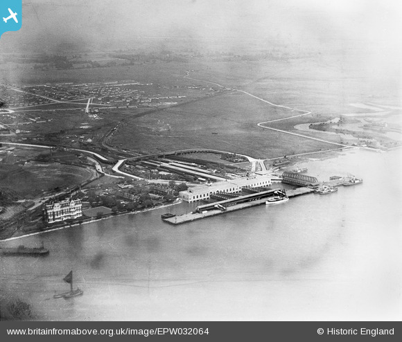
EPW032064 ENGLAND (1930). Tilbury Fort (later Tilbury Riverside) railway station and environs, Tilbury, 1930
© Copyright OpenStreetMap contributors and licensed by the OpenStreetMap Foundation. 2025. Cartography is licensed as CC BY-SA.
Nearby Images (8)
Details
| Title | [EPW032064] Tilbury Fort (later Tilbury Riverside) railway station and environs, Tilbury, 1930 |
| Reference | EPW032064 |
| Date | May-1930 |
| Link | |
| Place name | TILBURY |
| Parish | |
| District | |
| Country | ENGLAND |
| Easting / Northing | 564465, 175342 |
| Longitude / Latitude | 0.36730297469428, 51.452650276441 |
| National Grid Reference | TQ645753 |
Pins
Be the first to add a comment to this image!
User Comment Contributions
See EPW032065. |
 BigglesH |
Thursday 11th of April 2013 09:00:16 PM |


![[EPW032064] Tilbury Fort (later Tilbury Riverside) railway station and environs, Tilbury, 1930](http://britainfromabove.org.uk/sites/all/libraries/aerofilms-images/public/100x100/EPW/032/EPW032064.jpg)
![[EPW044217] Tilbury Docks, Tilbury Fort and the River Thames, Tilbury, 1934](http://britainfromabove.org.uk/sites/all/libraries/aerofilms-images/public/100x100/EPW/044/EPW044217.jpg)
![[EPW044223] Tilbury Docks, Tilbury, 1934](http://britainfromabove.org.uk/sites/all/libraries/aerofilms-images/public/100x100/EPW/044/EPW044223.jpg)
![[EPW032061] Tilbury Fort (later Tilbury Riverside) railway station and environs, Tilbury, 1930](http://britainfromabove.org.uk/sites/all/libraries/aerofilms-images/public/100x100/EPW/032/EPW032061.jpg)
![[EAW014601] RMS Strathaird in dock, Tilbury, 1948](http://britainfromabove.org.uk/sites/all/libraries/aerofilms-images/public/100x100/EAW/014/EAW014601.jpg)
![[EPW024911] The Tilbury Hotel, railway station and waterfront, with Tilbury Fort in the distance, Tilbury, 1928. This image has been produced from a damaged negative.](http://britainfromabove.org.uk/sites/all/libraries/aerofilms-images/public/100x100/EPW/024/EPW024911.jpg)
![[EPW032065] Tilbury Docks, Tilbury Fort (later Tilbury Riverside) railway station and environs, Tilbury, 1930](http://britainfromabove.org.uk/sites/all/libraries/aerofilms-images/public/100x100/EPW/032/EPW032065.jpg)
![[EPW032063] Tilbury Docks, Tilbury Fort (later Tilbury Riverside) railway station and environs, Tilbury, 1930](http://britainfromabove.org.uk/sites/all/libraries/aerofilms-images/public/100x100/EPW/032/EPW032063.jpg)