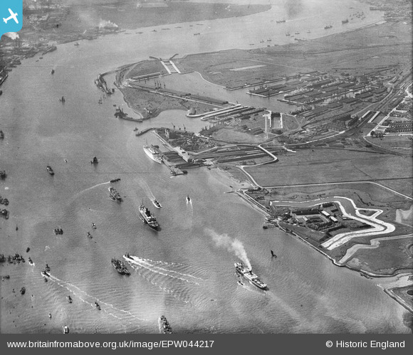
EPW044217 ENGLAND (1934). Tilbury Docks, Tilbury Fort and the River Thames, Tilbury, 1934
© Copyright OpenStreetMap contributors and licensed by the OpenStreetMap Foundation. 2025. Cartography is licensed as CC BY-SA.
Nearby Images (14)
Details
| Title | [EPW044217] Tilbury Docks, Tilbury Fort and the River Thames, Tilbury, 1934 |
| Reference | EPW044217 |
| Date | May-1934 |
| Link | |
| Place name | TILBURY |
| Parish | |
| District | |
| Country | ENGLAND |
| Easting / Northing | 564481, 175159 |
| Longitude / Latitude | 0.36744797406665, 51.451001391916 |
| National Grid Reference | TQ645752 |
Pins
Be the first to add a comment to this image!


![[EPW044217] Tilbury Docks, Tilbury Fort and the River Thames, Tilbury, 1934](http://britainfromabove.org.uk/sites/all/libraries/aerofilms-images/public/100x100/EPW/044/EPW044217.jpg)
![[EPW032061] Tilbury Fort (later Tilbury Riverside) railway station and environs, Tilbury, 1930](http://britainfromabove.org.uk/sites/all/libraries/aerofilms-images/public/100x100/EPW/032/EPW032061.jpg)
![[EPW032060] Tilbury Fort ( later Tilbury Riverside) railway station and environs, Tilbury, 1930](http://britainfromabove.org.uk/sites/all/libraries/aerofilms-images/public/100x100/EPW/032/EPW032060.jpg)
![[EPW044216] Tilbury Docks and the River Thames, Tilbury, 1934](http://britainfromabove.org.uk/sites/all/libraries/aerofilms-images/public/100x100/EPW/044/EPW044216.jpg)
![[EPW032063] Tilbury Docks, Tilbury Fort (later Tilbury Riverside) railway station and environs, Tilbury, 1930](http://britainfromabove.org.uk/sites/all/libraries/aerofilms-images/public/100x100/EPW/032/EPW032063.jpg)
![[EAW014601] RMS Strathaird in dock, Tilbury, 1948](http://britainfromabove.org.uk/sites/all/libraries/aerofilms-images/public/100x100/EAW/014/EAW014601.jpg)
![[EPW044227] Tilbury Landing Stage, Tilbury, 1934](http://britainfromabove.org.uk/sites/all/libraries/aerofilms-images/public/100x100/EPW/044/EPW044227.jpg)
![[EPW032064] Tilbury Fort (later Tilbury Riverside) railway station and environs, Tilbury, 1930](http://britainfromabove.org.uk/sites/all/libraries/aerofilms-images/public/100x100/EPW/032/EPW032064.jpg)
![[EPW044224] Tilbury Docks and the River Thames, Tilbury, 1934](http://britainfromabove.org.uk/sites/all/libraries/aerofilms-images/public/100x100/EPW/044/EPW044224.jpg)
![[EPW032065] Tilbury Docks, Tilbury Fort (later Tilbury Riverside) railway station and environs, Tilbury, 1930](http://britainfromabove.org.uk/sites/all/libraries/aerofilms-images/public/100x100/EPW/032/EPW032065.jpg)
![[EPW024911] The Tilbury Hotel, railway station and waterfront, with Tilbury Fort in the distance, Tilbury, 1928. This image has been produced from a damaged negative.](http://britainfromabove.org.uk/sites/all/libraries/aerofilms-images/public/100x100/EPW/024/EPW024911.jpg)
![[EAW014599] RMS Strathaird in dock, Tilbury, 1948](http://britainfromabove.org.uk/sites/all/libraries/aerofilms-images/public/100x100/EAW/014/EAW014599.jpg)
![[EPW032062] Tilbury Fort (later Tilbury Riverside) railway station and environs, Tilbury, from the south, 1930](http://britainfromabove.org.uk/sites/all/libraries/aerofilms-images/public/100x100/EPW/032/EPW032062.jpg)
![[EPW044223] Tilbury Docks, Tilbury, 1934](http://britainfromabove.org.uk/sites/all/libraries/aerofilms-images/public/100x100/EPW/044/EPW044223.jpg)