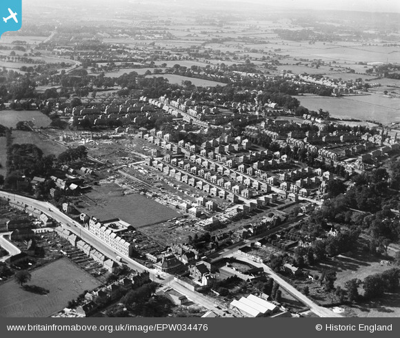
EPW034476 ENGLAND (1930). Housing under construction at Springfield Mount and environs, Kingsbury, 1930
© Copyright OpenStreetMap contributors and licensed by the OpenStreetMap Foundation. 2025. Cartography is licensed as CC BY-SA.
Nearby Images (8)
Details
| Title | [EPW034476] Housing under construction at Springfield Mount and environs, Kingsbury, 1930 |
| Reference | EPW034476 |
| Date | August-1930 |
| Link | |
| Place name | KINGSBURY |
| Parish | |
| District | |
| Country | ENGLAND |
| Easting / Northing | 521094, 188857 |
| Longitude / Latitude | -0.25196477519187, 51.585067844161 |
| National Grid Reference | TQ211889 |
Pins
 The Laird |
Sunday 18th of November 2018 02:41:06 PM | |
 colsouth111 |
Tuesday 19th of August 2014 09:20:04 PM | |
 Class31 |
Thursday 13th of March 2014 12:49:30 PM | |
This was Kingsbury Council School. It was a rather odd building, being like a long terrace, three to five storys high yet only one room deep; thus it was known as the Windjammer. It was bombed in World War 2 and was replaced by a block of flats. |
 colsouth111 |
Tuesday 19th of August 2014 09:13:37 PM |
I don't believe the entire tenement building was occupied by the national school, just the far end. I THink that the school had relocated to another part of Kingsbury by the time of the photo. The building did sustain bomb damage bomb during WW2, but remained in a partially unrepaired condition for some time afterwards. It was an odd looking place. It was built in the 1870s in an area that was, at that time, mostly countryside. It really does look like a piece of the Gorbals was dropped into rural Kingsbury. |
 The Laird |
Sunday 18th of November 2018 03:01:22 PM |
 Class31 |
Thursday 13th of March 2014 12:43:28 PM | |
 Class31 |
Wednesday 12th of March 2014 12:44:17 PM | |
 Class31 |
Wednesday 12th of March 2014 12:43:42 PM | |
 Class31 |
Wednesday 12th of March 2014 12:43:07 PM |


![[EPW034476] Housing under construction at Springfield Mount and environs, Kingsbury, 1930](http://britainfromabove.org.uk/sites/all/libraries/aerofilms-images/public/100x100/EPW/034/EPW034476.jpg)
![[EPW034482] Housing under construction at Springfield Mount and environs, Kingsbury, 1930](http://britainfromabove.org.uk/sites/all/libraries/aerofilms-images/public/100x100/EPW/034/EPW034482.jpg)
![[EPW034483] Housing under construction at Springfield Mount and environs, Kingsbury, 1930](http://britainfromabove.org.uk/sites/all/libraries/aerofilms-images/public/100x100/EPW/034/EPW034483.jpg)
![[EPW034473] Housing under construction at Derwent Avenue and environs, Kingsbury, 1930](http://britainfromabove.org.uk/sites/all/libraries/aerofilms-images/public/100x100/EPW/034/EPW034473.jpg)
![[EPW034479] Housing under construction at Springfield Mount and environs, Kingsbury, 1930](http://britainfromabove.org.uk/sites/all/libraries/aerofilms-images/public/100x100/EPW/034/EPW034479.jpg)
![[EPW034481] Housing under construction at Springfield Mount and environs, Kingsbury, 1930](http://britainfromabove.org.uk/sites/all/libraries/aerofilms-images/public/100x100/EPW/034/EPW034481.jpg)
![[EPW034480] Housing under construction at Springfield Mount and environs, Kingsbury, 1930](http://britainfromabove.org.uk/sites/all/libraries/aerofilms-images/public/100x100/EPW/034/EPW034480.jpg)
![[EPW034477] Housing under construction at Springfield Mount and environs, Kingsbury, 1930](http://britainfromabove.org.uk/sites/all/libraries/aerofilms-images/public/100x100/EPW/034/EPW034477.jpg)