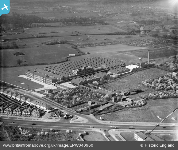
EPW040960 ENGLAND (1933). The Imperial Biscuit Works and environs, Brentford, 1933
© Copyright OpenStreetMap contributors and licensed by the OpenStreetMap Foundation. 2025. Cartography is licensed as CC BY-SA.
Nearby Images (12)
Details
| Title | [EPW040960] The Imperial Biscuit Works and environs, Brentford, 1933 |
| Reference | EPW040960 |
| Date | April-1933 |
| Link | |
| Place name | BRENTFORD |
| Parish | |
| District | |
| Country | ENGLAND |
| Easting / Northing | 516131, 177611 |
| Longitude / Latitude | -0.32728410471576, 51.485026806114 |
| National Grid Reference | TQ161776 |
Pins
 longshot |
Friday 13th of May 2022 11:14:22 PM | |
 The Laird |
Saturday 26th of December 2015 11:50:25 AM | |
 The Laird |
Saturday 30th of May 2015 10:47:21 AM | |
 Mozzy |
Thursday 25th of December 2014 10:18:49 PM | |
 Mozzy |
Thursday 25th of December 2014 10:14:34 PM |


![[EPW040960] The Imperial Biscuit Works and environs, Brentford, 1933](http://britainfromabove.org.uk/sites/all/libraries/aerofilms-images/public/100x100/EPW/040/EPW040960.jpg)
![[EPW034932] The Imperial Biscuit Works, Osterley, 1931](http://britainfromabove.org.uk/sites/all/libraries/aerofilms-images/public/100x100/EPW/034/EPW034932.jpg)
![[EPW034933] The Imperial Biscuit Works, Osterley, 1931](http://britainfromabove.org.uk/sites/all/libraries/aerofilms-images/public/100x100/EPW/034/EPW034933.jpg)
![[EPW040958] The Imperial Biscuit Works, Brentford, 1933](http://britainfromabove.org.uk/sites/all/libraries/aerofilms-images/public/100x100/EPW/040/EPW040958.jpg)
![[EPW032161] The Imperial Biscuit Works under construction and environs, Brentford, 1930](http://britainfromabove.org.uk/sites/all/libraries/aerofilms-images/public/100x100/EPW/032/EPW032161.jpg)
![[EPW031986] The MacFarlane Lang and Co Imperial Biscuit Works under construction, Osterley, 1930](http://britainfromabove.org.uk/sites/all/libraries/aerofilms-images/public/100x100/EPW/031/EPW031986.jpg)
![[EPW034934] The Imperial Biscuit Works and the Firestone Rubber Tyre Manufactory, Osterley, 1931](http://britainfromabove.org.uk/sites/all/libraries/aerofilms-images/public/100x100/EPW/034/EPW034934.jpg)
![[EPW051810] The Gillette Factory, Osterley, 1936. This image has been produced from a copy-negative.](http://britainfromabove.org.uk/sites/all/libraries/aerofilms-images/public/100x100/EPW/051/EPW051810.jpg)
![[EPW027556] Housing under construction between the Great West Road and Syon Lane, Osterley, 1929. This image has been produced from a copy-negative.](http://britainfromabove.org.uk/sites/all/libraries/aerofilms-images/public/100x100/EPW/027/EPW027556.jpg)
![[EPW059345] The Gillette Factory, Imperial Biscuit Works and Great West Road, Osterley, 1938](http://britainfromabove.org.uk/sites/all/libraries/aerofilms-images/public/100x100/EPW/059/EPW059345.jpg)
![[EPW060953] The Imperial Biscuit Works, Gillette Factory and environs, Osterley, 1939](http://britainfromabove.org.uk/sites/all/libraries/aerofilms-images/public/100x100/EPW/060/EPW060953.jpg)
![[EPW035030] The Imperial Biscuit Works and the Great West Road, Osterley, 1931](http://britainfromabove.org.uk/sites/all/libraries/aerofilms-images/public/100x100/EPW/035/EPW035030.jpg)
