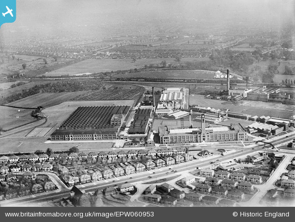
EPW060953 ENGLAND (1939). The Imperial Biscuit Works, Gillette Factory and environs, Osterley, 1939
© Copyright OpenStreetMap contributors and licensed by the OpenStreetMap Foundation. 2025. Cartography is licensed as CC BY-SA.
Nearby Images (16)
Details
| Title | [EPW060953] The Imperial Biscuit Works, Gillette Factory and environs, Osterley, 1939 |
| Reference | EPW060953 |
| Date | 12-May-1939 |
| Link | |
| Place name | OSTERLEY |
| Parish | |
| District | |
| Country | ENGLAND |
| Easting / Northing | 516241, 177757 |
| Longitude / Latitude | -0.32565234864067, 51.486316550942 |
| National Grid Reference | TQ162778 |
Pins
 Wordy |
Sunday 4th of May 2014 08:44:08 AM |


![[EPW060953] The Imperial Biscuit Works, Gillette Factory and environs, Osterley, 1939](http://britainfromabove.org.uk/sites/all/libraries/aerofilms-images/public/100x100/EPW/060/EPW060953.jpg)
![[EPW059345] The Gillette Factory, Imperial Biscuit Works and Great West Road, Osterley, 1938](http://britainfromabove.org.uk/sites/all/libraries/aerofilms-images/public/100x100/EPW/059/EPW059345.jpg)
![[EAW050745] The Firestone Tyre and Rubber Co Factory off Great West Road and environs, Brentford, 1953. This image was marked by Aerofilms Ltd for photo editing.](http://britainfromabove.org.uk/sites/all/libraries/aerofilms-images/public/100x100/EAW/050/EAW050745.jpg)
![[EAW050744] The Firestone Tyre and Rubber Co Factory off Great West Road and environs, Brentford, 1953. This image was marked by Aerofilms Ltd for photo editing.](http://britainfromabove.org.uk/sites/all/libraries/aerofilms-images/public/100x100/EAW/050/EAW050744.jpg)
![[EPW034932] The Imperial Biscuit Works, Osterley, 1931](http://britainfromabove.org.uk/sites/all/libraries/aerofilms-images/public/100x100/EPW/034/EPW034932.jpg)
![[EPW040960] The Imperial Biscuit Works and environs, Brentford, 1933](http://britainfromabove.org.uk/sites/all/libraries/aerofilms-images/public/100x100/EPW/040/EPW040960.jpg)
![[EPW034933] The Imperial Biscuit Works, Osterley, 1931](http://britainfromabove.org.uk/sites/all/libraries/aerofilms-images/public/100x100/EPW/034/EPW034933.jpg)
![[EPW040958] The Imperial Biscuit Works, Brentford, 1933](http://britainfromabove.org.uk/sites/all/libraries/aerofilms-images/public/100x100/EPW/040/EPW040958.jpg)
![[EPW022998] The Firestone Tyre and Rubber Co Manufactory under construction, Brentford, 1928. This image has been produced from a copy-negative.](http://britainfromabove.org.uk/sites/all/libraries/aerofilms-images/public/100x100/EPW/022/EPW022998.jpg)
![[EAW050743] The Firestone Tyre and Rubber Co Factory off Great West Road, Brentford, 1953. This image was marked by Aerofilms Ltd for photo editing.](http://britainfromabove.org.uk/sites/all/libraries/aerofilms-images/public/100x100/EAW/050/EAW050743.jpg)
![[EAW050742] The Firestone Tyre and Rubber Co Factory off Great West Road, Brentford, 1953. This image was marked by Aerofilms Ltd for photo editing.](http://britainfromabove.org.uk/sites/all/libraries/aerofilms-images/public/100x100/EAW/050/EAW050742.jpg)
![[EPW031986] The MacFarlane Lang and Co Imperial Biscuit Works under construction, Osterley, 1930](http://britainfromabove.org.uk/sites/all/libraries/aerofilms-images/public/100x100/EPW/031/EPW031986.jpg)
![[EPW032161] The Imperial Biscuit Works under construction and environs, Brentford, 1930](http://britainfromabove.org.uk/sites/all/libraries/aerofilms-images/public/100x100/EPW/032/EPW032161.jpg)
![[EAW050739] The Firestone Tyre and Rubber Co Factory off Great West Road, Brentford, 1953. This image was marked by Aerofilms Ltd for photo editing.](http://britainfromabove.org.uk/sites/all/libraries/aerofilms-images/public/100x100/EAW/050/EAW050739.jpg)
![[EPW051810] The Gillette Factory, Osterley, 1936. This image has been produced from a copy-negative.](http://britainfromabove.org.uk/sites/all/libraries/aerofilms-images/public/100x100/EPW/051/EPW051810.jpg)
![[EPW034934] The Imperial Biscuit Works and the Firestone Rubber Tyre Manufactory, Osterley, 1931](http://britainfromabove.org.uk/sites/all/libraries/aerofilms-images/public/100x100/EPW/034/EPW034934.jpg)