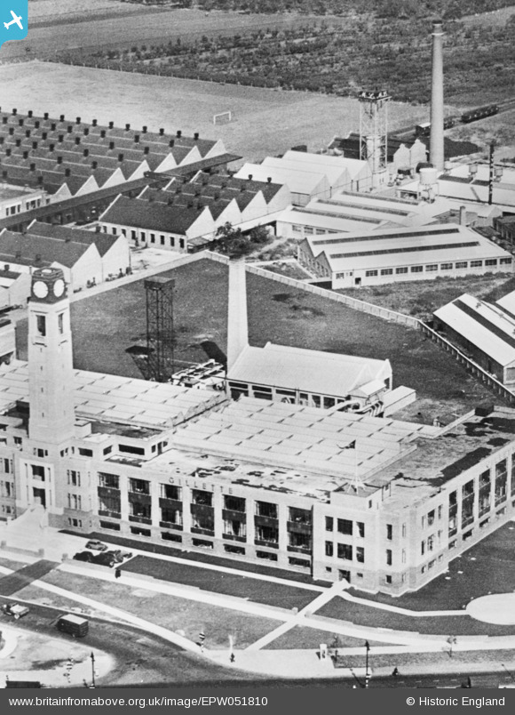
EPW051810 ENGLAND (1936). The Gillette Factory, Osterley, 1936. This image has been produced from a copy-negative.
© Copyright OpenStreetMap contributors and licensed by the OpenStreetMap Foundation. 2025. Cartography is licensed as CC BY-SA.
Nearby Images (21)
Details
| Title | [EPW051810] The Gillette Factory, Osterley, 1936. This image has been produced from a copy-negative. |
| Reference | EPW051810 |
| Date | September-1936 |
| Link | |
| Place name | OSTERLEY |
| Parish | |
| District | |
| Country | ENGLAND |
| Easting / Northing | 516240, 177520 |
| Longitude / Latitude | -0.32574478548458, 51.484186437794 |
| National Grid Reference | TQ162775 |
Pins
Be the first to add a comment to this image!
User Comment Contributions
Gilette Building, Brentford, 22/07/2015 |
 Class31 |
Friday 24th of July 2015 06:37:09 AM |


![[EPW051810] The Gillette Factory, Osterley, 1936. This image has been produced from a copy-negative.](http://britainfromabove.org.uk/sites/all/libraries/aerofilms-images/public/100x100/EPW/051/EPW051810.jpg)
![[EPW059345] The Gillette Factory, Imperial Biscuit Works and Great West Road, Osterley, 1938](http://britainfromabove.org.uk/sites/all/libraries/aerofilms-images/public/100x100/EPW/059/EPW059345.jpg)
![[EPW040960] The Imperial Biscuit Works and environs, Brentford, 1933](http://britainfromabove.org.uk/sites/all/libraries/aerofilms-images/public/100x100/EPW/040/EPW040960.jpg)
![[EPW034932] The Imperial Biscuit Works, Osterley, 1931](http://britainfromabove.org.uk/sites/all/libraries/aerofilms-images/public/100x100/EPW/034/EPW034932.jpg)
![[EPW034933] The Imperial Biscuit Works, Osterley, 1931](http://britainfromabove.org.uk/sites/all/libraries/aerofilms-images/public/100x100/EPW/034/EPW034933.jpg)
![[EPW040958] The Imperial Biscuit Works, Brentford, 1933](http://britainfromabove.org.uk/sites/all/libraries/aerofilms-images/public/100x100/EPW/040/EPW040958.jpg)
![[EPW032161] The Imperial Biscuit Works under construction and environs, Brentford, 1930](http://britainfromabove.org.uk/sites/all/libraries/aerofilms-images/public/100x100/EPW/032/EPW032161.jpg)
![[EPR000524] Sir William Burnett & Co (Chemicals) Ltd Soldering Fluid Manufactory on the Great West Road, Spring Grove, 1935](http://britainfromabove.org.uk/sites/all/libraries/aerofilms-images/public/100x100/EPR/000/EPR000524.jpg)
![[EAW050745] The Firestone Tyre and Rubber Co Factory off Great West Road and environs, Brentford, 1953. This image was marked by Aerofilms Ltd for photo editing.](http://britainfromabove.org.uk/sites/all/libraries/aerofilms-images/public/100x100/EAW/050/EAW050745.jpg)
![[EPR000525] Sir William Burnett & Co (Chemicals) Ltd Soldering Fluid Manufactory on the Great West Road, Spring Grove, 1935](http://britainfromabove.org.uk/sites/all/libraries/aerofilms-images/public/100x100/EPR/000/EPR000525.jpg)
![[EPW050304] Housing alongside the Great West Road, the Gillette factory under construction and the Imperial Biscuit Works, Brentford End, 1936](http://britainfromabove.org.uk/sites/all/libraries/aerofilms-images/public/100x100/EPW/050/EPW050304.jpg)
![[EPW031986] The MacFarlane Lang and Co Imperial Biscuit Works under construction, Osterley, 1930](http://britainfromabove.org.uk/sites/all/libraries/aerofilms-images/public/100x100/EPW/031/EPW031986.jpg)
![[EPW034934] The Imperial Biscuit Works and the Firestone Rubber Tyre Manufactory, Osterley, 1931](http://britainfromabove.org.uk/sites/all/libraries/aerofilms-images/public/100x100/EPW/034/EPW034934.jpg)
![[EPW060953] The Imperial Biscuit Works, Gillette Factory and environs, Osterley, 1939](http://britainfromabove.org.uk/sites/all/libraries/aerofilms-images/public/100x100/EPW/060/EPW060953.jpg)
![[EPR000527] Brittol House and the Coty Ltd Perfume Manufactory on the Great West Road, Spring Grove, 1935](http://britainfromabove.org.uk/sites/all/libraries/aerofilms-images/public/100x100/EPR/000/EPR000527.jpg)
![[EAW050744] The Firestone Tyre and Rubber Co Factory off Great West Road and environs, Brentford, 1953. This image was marked by Aerofilms Ltd for photo editing.](http://britainfromabove.org.uk/sites/all/libraries/aerofilms-images/public/100x100/EAW/050/EAW050744.jpg)
![[EPW035036] The Great West Road and construction of new housing on Syon Lane, Osterley, 1931](http://britainfromabove.org.uk/sites/all/libraries/aerofilms-images/public/100x100/EPW/035/EPW035036.jpg)
![[EAW050739] The Firestone Tyre and Rubber Co Factory off Great West Road, Brentford, 1953. This image was marked by Aerofilms Ltd for photo editing.](http://britainfromabove.org.uk/sites/all/libraries/aerofilms-images/public/100x100/EAW/050/EAW050739.jpg)
![[EPW035030] The Imperial Biscuit Works and the Great West Road, Osterley, 1931](http://britainfromabove.org.uk/sites/all/libraries/aerofilms-images/public/100x100/EPW/035/EPW035030.jpg)
![[EPW022998] The Firestone Tyre and Rubber Co Manufactory under construction, Brentford, 1928. This image has been produced from a copy-negative.](http://britainfromabove.org.uk/sites/all/libraries/aerofilms-images/public/100x100/EPW/022/EPW022998.jpg)
![[EAW050742] The Firestone Tyre and Rubber Co Factory off Great West Road, Brentford, 1953. This image was marked by Aerofilms Ltd for photo editing.](http://britainfromabove.org.uk/sites/all/libraries/aerofilms-images/public/100x100/EAW/050/EAW050742.jpg)