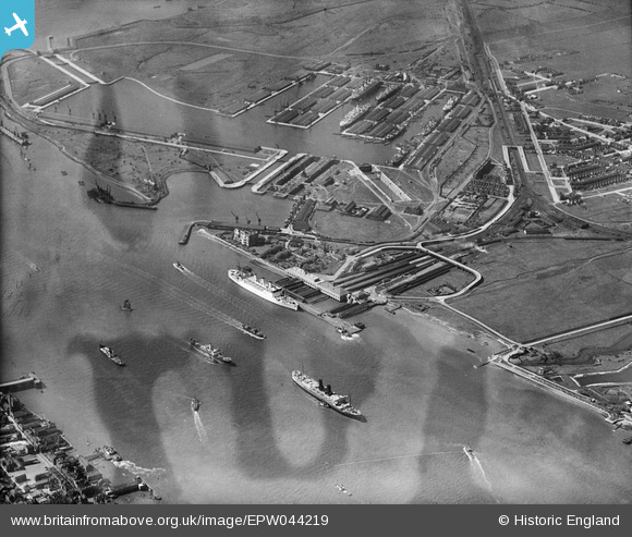
EPW044219 ENGLAND (1934). Tilbury Docks, Tilbury, 1934
© Copyright OpenStreetMap contributors and licensed by the OpenStreetMap Foundation. 2025. Cartography is licensed as CC BY-SA.
Nearby Images (19)
Details
| Title | [EPW044219] Tilbury Docks, Tilbury, 1934 |
| Reference | EPW044219 |
| Date | May-1934 |
| Link | |
| Place name | TILBURY |
| Parish | |
| District | |
| Country | ENGLAND |
| Easting / Northing | 564192, 175208 |
| Longitude / Latitude | 0.36331481980539, 51.451525538333 |
| National Grid Reference | TQ642752 |
Pins
 Billy Turner |
Tuesday 29th of December 2015 06:53:30 PM |


![[EPW044219] Tilbury Docks, Tilbury, 1934](http://britainfromabove.org.uk/sites/all/libraries/aerofilms-images/public/100x100/EPW/044/EPW044219.jpg)
![[EPW044226] Tilbury Landing Stage and the docks, Tilbury, 1934](http://britainfromabove.org.uk/sites/all/libraries/aerofilms-images/public/100x100/EPW/044/EPW044226.jpg)
![[EPW024911] The Tilbury Hotel, railway station and waterfront, with Tilbury Fort in the distance, Tilbury, 1928. This image has been produced from a damaged negative.](http://britainfromabove.org.uk/sites/all/libraries/aerofilms-images/public/100x100/EPW/024/EPW024911.jpg)
![[EPW032065] Tilbury Docks, Tilbury Fort (later Tilbury Riverside) railway station and environs, Tilbury, 1930](http://britainfromabove.org.uk/sites/all/libraries/aerofilms-images/public/100x100/EPW/032/EPW032065.jpg)
![[EPW044225] Tilbury Riverside Station and the docks, Tilbury, 1934](http://britainfromabove.org.uk/sites/all/libraries/aerofilms-images/public/100x100/EPW/044/EPW044225.jpg)
![[EAW014598] RMS Strathaird in dock, Tilbury, 1948](http://britainfromabove.org.uk/sites/all/libraries/aerofilms-images/public/100x100/EAW/014/EAW014598.jpg)
![[EPW044223] Tilbury Docks, Tilbury, 1934](http://britainfromabove.org.uk/sites/all/libraries/aerofilms-images/public/100x100/EPW/044/EPW044223.jpg)
![[EAW014601] RMS Strathaird in dock, Tilbury, 1948](http://britainfromabove.org.uk/sites/all/libraries/aerofilms-images/public/100x100/EAW/014/EAW014601.jpg)
![[EAW014599] RMS Strathaird in dock, Tilbury, 1948](http://britainfromabove.org.uk/sites/all/libraries/aerofilms-images/public/100x100/EAW/014/EAW014599.jpg)
![[EPW032063] Tilbury Docks, Tilbury Fort (later Tilbury Riverside) railway station and environs, Tilbury, 1930](http://britainfromabove.org.uk/sites/all/libraries/aerofilms-images/public/100x100/EPW/032/EPW032063.jpg)
![[EAW014600] RMS Strathaird in dock, Tilbury, 1948](http://britainfromabove.org.uk/sites/all/libraries/aerofilms-images/public/100x100/EAW/014/EAW014600.jpg)
![[EPW044224] Tilbury Docks and the River Thames, Tilbury, 1934](http://britainfromabove.org.uk/sites/all/libraries/aerofilms-images/public/100x100/EPW/044/EPW044224.jpg)
![[EAW034858] Tilbury Docks, Tilbury, 1951. This image has been produced from a print.](http://britainfromabove.org.uk/sites/all/libraries/aerofilms-images/public/100x100/EAW/034/EAW034858.jpg)
![[EAW034857] Tilbury Docks, Tilbury, 1951. This image has been produced from a print.](http://britainfromabove.org.uk/sites/all/libraries/aerofilms-images/public/100x100/EAW/034/EAW034857.jpg)
![[EPW032061] Tilbury Fort (later Tilbury Riverside) railway station and environs, Tilbury, 1930](http://britainfromabove.org.uk/sites/all/libraries/aerofilms-images/public/100x100/EPW/032/EPW032061.jpg)
![[EPW044227] Tilbury Landing Stage, Tilbury, 1934](http://britainfromabove.org.uk/sites/all/libraries/aerofilms-images/public/100x100/EPW/044/EPW044227.jpg)
![[EAW028721] The SS Himalaya at the Landing Stage of Tilbury Docks, Tilbury, 1950](http://britainfromabove.org.uk/sites/all/libraries/aerofilms-images/public/100x100/EAW/028/EAW028721.jpg)
![[EPW032062] Tilbury Fort (later Tilbury Riverside) railway station and environs, Tilbury, from the south, 1930](http://britainfromabove.org.uk/sites/all/libraries/aerofilms-images/public/100x100/EPW/032/EPW032062.jpg)
![[EPW044216] Tilbury Docks and the River Thames, Tilbury, 1934](http://britainfromabove.org.uk/sites/all/libraries/aerofilms-images/public/100x100/EPW/044/EPW044216.jpg)
