
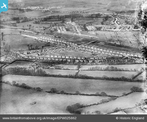
EPW025862 ENGLAND (1929). New housing at Wood End, Northolt, 1929
© Copyright OpenStreetMap contributors and licensed by the OpenStreetMap Foundation. 2024. Cartography is licensed as CC BY-SA.
Nearby Images (11)
EPW025862

EPW025867

EPW025871

EPW025869

EPW025868

EPW025866

EPW025870

EPW025865

EPW025864

EPW025863

EPW060179

Details
| Title | [EPW025862] New housing at Wood End, Northolt, 1929 |
| Reference | EPW025862 |
| Date | March-1929 |
| Link | |
| Place name | NORTHOLT |
| Parish | |
| District | |
| Country | ENGLAND |
| Easting / Northing | 514392, 185490 |
| Longitude / Latitude | -0.34976251389333, 51.556203645285 |
| National Grid Reference | TQ144855 |
Pins
 Des Elmes |
Tuesday 5th of April 2016 02:31:44 AM | |
Des Elmes |
Tuesday 5th of April 2016 02:31:10 AM | |
Des Elmes |
Tuesday 5th of April 2016 02:30:33 AM | |
Des Elmes |
Tuesday 5th of April 2016 02:29:37 AM | |
Des Elmes |
Tuesday 5th of April 2016 02:28:47 AM | |
Des Elmes |
Tuesday 5th of April 2016 02:28:16 AM | |
 Class31 |
Friday 28th of September 2012 08:12:59 PM | |
Class31 |
Friday 28th of September 2012 08:12:40 PM | |
Class31 |
Friday 28th of September 2012 08:12:21 PM | |
Class31 |
Friday 28th of September 2012 08:12:07 PM | |
 Paul |
Tuesday 18th of September 2012 08:06:21 PM | |
Paul |
Tuesday 18th of September 2012 08:02:59 PM |