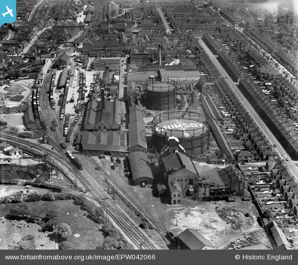
EPW042066 ENGLAND (1933). Grimsby Gas Works, Sheepfold Street and environs, Grimsby, 1933
© Copyright OpenStreetMap contributors and licensed by the OpenStreetMap Foundation. 2024. Cartography is licensed as CC BY-SA.
Nearby Images (14)
EPW042066

EPW042068

EPW042071

EPW042069

EPW042067

EPW053392

EAW052054

EAW052052

EPW042804

EPW042070

EAW052049

EAW052051

EAW052053

EPW042807

Details
| Title | [EPW042066] Grimsby Gas Works, Sheepfold Street and environs, Grimsby, 1933 |
| Reference | EPW042066 |
| Date | June-1933 |
| Link | |
| Place name | GRIMSBY |
| Parish | |
| District | |
| Country | ENGLAND |
| Easting / Northing | 527359, 409125 |
| Longitude / Latitude | -0.076847163760555, 53.563019889085 |
| National Grid Reference | TA274091 |
Pins
 Vauni |
Tuesday 10th of May 2016 09:16:12 AM | |
Brightonboy |
Tuesday 10th of May 2016 08:19:19 AM | |
Brightonboy |
Tuesday 10th of May 2016 08:17:31 AM | |
Brightonboy |
Tuesday 10th of May 2016 08:16:04 AM | |
 Class31 |
Monday 9th of May 2016 09:19:07 PM | |
Class31 |
Tuesday 4th of March 2014 09:00:24 AM | |
Class31 |
Tuesday 4th of March 2014 08:59:50 AM | |
Class31 |
Tuesday 4th of March 2014 08:58:22 AM | |
Class31 |
Tuesday 4th of March 2014 08:57:57 AM |