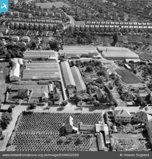
EAW032289 ENGLAND (1950). Nursery between Southdown Road and Coronation Avenue, Southdown, 1950
© Copyright OpenStreetMap contributors and licensed by the OpenStreetMap Foundation. 2025. Cartography is licensed as CC BY-SA.
Nearby Images (20)
EAW032289

EAW032291

EAW032287

EAW032292

EAW026390

EAW026394

EAW026393

EAW026396

EPW022216

EAW026392

EAW026395

EAW026389

EAW032286

EAW026391

EAW032290

EAW032288

EPW022215

EPW048401

EPW022213

EPW022218

Details
| Title | [EAW032289] Nursery between Southdown Road and Coronation Avenue, Southdown, 1950 |
| Reference | EAW032289 |
| Date | 5-September-1950 |
| Link | |
| Place name | SOUTHDOWN |
| Parish | |
| District | |
| Country | ENGLAND |
| Easting / Northing | 373001, 163677 |
| Longitude / Latitude | -2.3879071368196, 51.37101085312 |
| National Grid Reference | ST730637 |
Pins
 Class31 |
Friday 27th of March 2015 06:46:16 PM | |
Class31 |
Friday 27th of March 2015 06:44:56 PM | |
 H Campbell |
Monday 9th of February 2015 09:30:36 PM | |
H Campbell |
Monday 9th of February 2015 09:28:14 PM | |
H Campbell |
Monday 9th of February 2015 09:28:12 PM | |
Class31 |
Monday 1st of December 2014 03:48:03 PM |