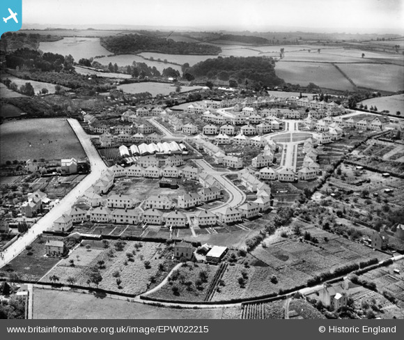
EPW022215 ENGLAND (1928). Southdown, Bath, 1928
© Copyright OpenStreetMap contributors and licensed by the OpenStreetMap Foundation. 2025. Cartography is licensed as CC BY-SA.
Nearby Images (17)
EPW022215

EPW048401

EPW022213

EPW022218

EPW048400

EPW022216

EPW022217

EAW032290

EAW032286

EAW026392

EAW032288

EAW026391

EAW032292

EPW022214

EAW032289

EAW032287

EAW032291

Details
| Title | [EPW022215] Southdown, Bath, 1928 |
| Reference | EPW022215 |
| Date | 30-July-1928 |
| Link | |
| Place name | BATH |
| Parish | |
| District | |
| Country | ENGLAND |
| Easting / Northing | 372807, 163526 |
| Longitude / Latitude | -2.3906827991002, 51.369643725941 |
| National Grid Reference | ST728635 |
Pins
 H Campbell |
Saturday 11th of January 2014 02:40:22 PM | |
H Campbell |
Saturday 11th of January 2014 02:38:16 PM | |
 Class31 |
Tuesday 10th of July 2012 11:51:42 AM | |
Class31 |
Tuesday 10th of July 2012 11:51:03 AM | |
Class31 |
Tuesday 10th of July 2012 11:50:19 AM | |
ooo-arr27 |
Saturday 30th of June 2012 01:28:07 PM |