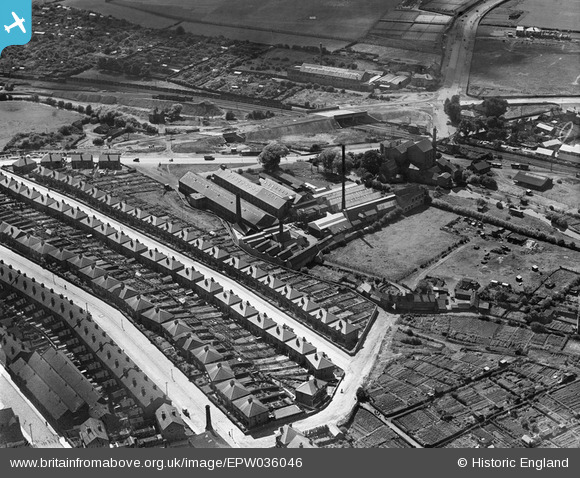
EPW036046 ENGLAND (1931). The Bobbers Mill Bleaching and Dyeing Works, Chadwick Road and Bobbers Mill Bridge under construction, Nottingham, 1931
© Copyright OpenStreetMap contributors and licensed by the OpenStreetMap Foundation. 2025. Cartography is licensed as CC BY-SA.
Nearby Images (16)
Details
| Title | [EPW036046] The Bobbers Mill Bleaching and Dyeing Works, Chadwick Road and Bobbers Mill Bridge under construction, Nottingham, 1931 |
| Reference | EPW036046 |
| Date | July-1931 |
| Link | |
| Place name | NOTTINGHAM |
| Parish | |
| District | |
| Country | ENGLAND |
| Easting / Northing | 455148, 341378 |
| Longitude / Latitude | -1.1787957543871, 52.966611679671 |
| National Grid Reference | SK551414 |
Pins
 KC |
Monday 28th of August 2023 10:50:20 AM |


![[EPW036046] The Bobbers Mill Bleaching and Dyeing Works, Chadwick Road and Bobbers Mill Bridge under construction, Nottingham, 1931](http://britainfromabove.org.uk/sites/all/libraries/aerofilms-images/public/100x100/EPW/036/EPW036046.jpg)
![[EPW036048] The Bobbers Mill Bleaching and Dyeing Works, Chadwick Road and Bobbers Mill Bridge under construction, Nottingham, 1931](http://britainfromabove.org.uk/sites/all/libraries/aerofilms-images/public/100x100/EPW/036/EPW036048.jpg)
![[EPW036047] The Bobbers Mill Bleaching and Dyeing Works, Chadwick Road and the Bobbers Corn Mill, Nottingham, 1931](http://britainfromabove.org.uk/sites/all/libraries/aerofilms-images/public/100x100/EPW/036/EPW036047.jpg)
![[EPW036042] The Bobbers Mill Bleaching and Dyeing Works, Chadwick Road and Bobbers Mill Bridge under construction, Nottingham, 1931](http://britainfromabove.org.uk/sites/all/libraries/aerofilms-images/public/100x100/EPW/036/EPW036042.jpg)
![[EPW036040] The Bobbers Mill Bleaching and Dyeing Works and Chadwick Road, Nottingham, 1931](http://britainfromabove.org.uk/sites/all/libraries/aerofilms-images/public/100x100/EPW/036/EPW036040.jpg)
![[EPW036039] The Bobbers Mill Bleaching and Dyeing Works, Chadwick Road and Bobbers Mill Bridge under construction, Nottingham, 1931. This image has been produced from a damaged negative.](http://britainfromabove.org.uk/sites/all/libraries/aerofilms-images/public/100x100/EPW/036/EPW036039.jpg)
![[EPW036043] The Bobbers Mill Bleaching and Dyeing Works, Chadwick Road and Bobbers Mill Bridge under construction, Nottingham, 1931](http://britainfromabove.org.uk/sites/all/libraries/aerofilms-images/public/100x100/EPW/036/EPW036043.jpg)
![[EPW036044] The Bobbers Mill Bleaching and Dyeing Works, Chadwick Road and Bobbers Mill Bridge under construction, Nottingham, 1931](http://britainfromabove.org.uk/sites/all/libraries/aerofilms-images/public/100x100/EPW/036/EPW036044.jpg)
![[EPW036041] The Bobbers Mill Bleaching and Dyeing Works, Chadwick Road and Bobbers Mill Bridge under construction, Nottingham, 1931. This image has been produced from a damaged negative.](http://britainfromabove.org.uk/sites/all/libraries/aerofilms-images/public/100x100/EPW/036/EPW036041.jpg)
![[EPW036045] The Bobbers Mill Bleaching and Dyeing Works, Chadwick Road and Bobbers Mill Bridge under construction, Nottingham, 1931](http://britainfromabove.org.uk/sites/all/libraries/aerofilms-images/public/100x100/EPW/036/EPW036045.jpg)
![[EPW054123] Robert Shaw & Co Ascot Works, Nottingham, 1937](http://britainfromabove.org.uk/sites/all/libraries/aerofilms-images/public/100x100/EPW/054/EPW054123.jpg)
![[EPW054124] Robert Shaw & Co Ascot Works, Nottingham, 1937](http://britainfromabove.org.uk/sites/all/libraries/aerofilms-images/public/100x100/EPW/054/EPW054124.jpg)
![[EPW054121] Robert Shaw & Co Ascot Works, Nottingham, 1937](http://britainfromabove.org.uk/sites/all/libraries/aerofilms-images/public/100x100/EPW/054/EPW054121.jpg)
![[EPW054122] Robert Shaw & Co Ascot Works, Nottingham, 1937](http://britainfromabove.org.uk/sites/all/libraries/aerofilms-images/public/100x100/EPW/054/EPW054122.jpg)
![[EPW054120] Robert Shaw & Co Ascot Works and environs, Nottingham, 1937](http://britainfromabove.org.uk/sites/all/libraries/aerofilms-images/public/100x100/EPW/054/EPW054120.jpg)
![[EPW054119] Robert Shaw & Co Ascot Works, Nottingham, 1937](http://britainfromabove.org.uk/sites/all/libraries/aerofilms-images/public/100x100/EPW/054/EPW054119.jpg)