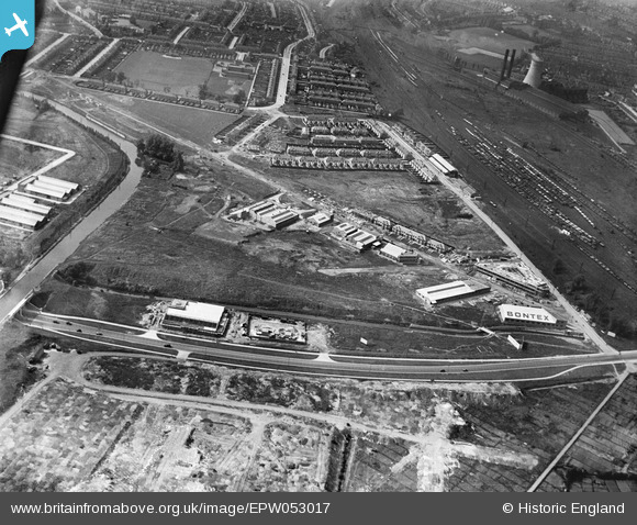
EPW053017 ENGLAND (1937). Construction of housing and industrial buildings along Beresford Avenue and environs, Alperton, 1937
© Copyright OpenStreetMap contributors and licensed by the OpenStreetMap Foundation. 2025. Cartography is licensed as CC BY-SA.
Nearby Images (42)
Details
| Title | [EPW053017] Construction of housing and industrial buildings along Beresford Avenue and environs, Alperton, 1937 |
| Reference | EPW053017 |
| Date | 17-May-1937 |
| Link | |
| Place name | ALPERTON |
| Parish | |
| District | |
| Country | ENGLAND |
| Easting / Northing | 519315, 183832 |
| Longitude / Latitude | -0.27933870616135, 51.540280946986 |
| National Grid Reference | TQ193838 |
Pins
 The Laird |
Friday 3rd of February 2017 08:57:44 PM | |
 The Laird |
Friday 3rd of February 2017 08:52:29 PM | |
 The Laird |
Friday 3rd of February 2017 08:48:57 PM | |
 Rudgey |
Monday 3rd of October 2016 08:42:25 PM |


![[EPW053017] Construction of housing and industrial buildings along Beresford Avenue and environs, Alperton, 1937](http://britainfromabove.org.uk/sites/all/libraries/aerofilms-images/public/100x100/EPW/053/EPW053017.jpg)
![[EPW051675] Brent Junction, construction of Beresford Avenue and housing at Kenmere Gardens, Alperton, 1936](http://britainfromabove.org.uk/sites/all/libraries/aerofilms-images/public/100x100/EPW/051/EPW051675.jpg)
![[EPW051676] Construction of Beresford Avenue and housing at Kenmere Gardens, Alperton, 1936](http://britainfromabove.org.uk/sites/all/libraries/aerofilms-images/public/100x100/EPW/051/EPW051676.jpg)
![[EPW053022] Construction of housing and industrial buildings along Beresford Avenue and Brent Junction, Alperton, 1937](http://britainfromabove.org.uk/sites/all/libraries/aerofilms-images/public/100x100/EPW/053/EPW053022.jpg)
![[EPW056468] The offices of Aerofilms Ltd on Beresford Avenue, Alperton, 1938](http://britainfromabove.org.uk/sites/all/libraries/aerofilms-images/public/100x100/EPW/056/EPW056468.jpg)
![[EPW052465] The offices of Aerofilms Ltd on Beresford Avenue, Alperton, 1937. This image has been produced from a print.](http://britainfromabove.org.uk/sites/all/libraries/aerofilms-images/public/100x100/EPW/052/EPW052465.jpg)
![[EPW056467] The offices of Aerofilms Ltd on Beresford Avenue, Alperton, 1938](http://britainfromabove.org.uk/sites/all/libraries/aerofilms-images/public/100x100/EPW/056/EPW056467.jpg)
![[EPW056366] Aerofilms Ltd Premises on Beresford Avenue, Alperton, 1938](http://britainfromabove.org.uk/sites/all/libraries/aerofilms-images/public/100x100/EPW/056/EPW056366.jpg)
![[EPW051679] Brent Junction, construction of Beresford Avenue and housing at Kenmere Gardens, Alperton, 1936](http://britainfromabove.org.uk/sites/all/libraries/aerofilms-images/public/100x100/EPW/051/EPW051679.jpg)
![[EPW051677] Construction of Beresford Avenue and housing at Kenmere Gardens and environs, Alperton, 1936](http://britainfromabove.org.uk/sites/all/libraries/aerofilms-images/public/100x100/EPW/051/EPW051677.jpg)
![[EPW053019] The Grand Union Canal, construction of housing and industrial buildings along Beresford Avenue and environs, Alperton, 1937](http://britainfromabove.org.uk/sites/all/libraries/aerofilms-images/public/100x100/EPW/053/EPW053019.jpg)
![[EPW051672] Brent Junction and environs, Alperton, 1936](http://britainfromabove.org.uk/sites/all/libraries/aerofilms-images/public/100x100/EPW/051/EPW051672.jpg)
![[EPW051680] Brent Junction, construction of Beresford Avenue and environs, Alperton, 1936](http://britainfromabove.org.uk/sites/all/libraries/aerofilms-images/public/100x100/EPW/051/EPW051680.jpg)
![[EPW053016] Construction of housing and industrial buildings along Beresford Avenue, Alperton, 1937](http://britainfromabove.org.uk/sites/all/libraries/aerofilms-images/public/100x100/EPW/053/EPW053016.jpg)
![[EPW052467] The offices of Aerofilms Ltd and surrounding works and housing under construction off Beresford Avenue, Alperton, 1937. This image has been produced from a print.](http://britainfromabove.org.uk/sites/all/libraries/aerofilms-images/public/100x100/EPW/052/EPW052467.jpg)
![[EPW053021] Construction of housing and industrial buildings along Beresford Avenue, Alperton, 1937](http://britainfromabove.org.uk/sites/all/libraries/aerofilms-images/public/100x100/EPW/053/EPW053021.jpg)
![[EPW051674] Construction of Beresford Avenue and housing at Kenmere Gardens and environs, Alperton, 1936](http://britainfromabove.org.uk/sites/all/libraries/aerofilms-images/public/100x100/EPW/051/EPW051674.jpg)
![[EPW051678] Construction of Beresford Avenue and housing at Kenmere Gardens and environs, Alperton, 1936](http://britainfromabove.org.uk/sites/all/libraries/aerofilms-images/public/100x100/EPW/051/EPW051678.jpg)
![[EPW053018] Construction of housing and industrial buildings along Beresford Avenue and environs, Alperton, 1937](http://britainfromabove.org.uk/sites/all/libraries/aerofilms-images/public/100x100/EPW/053/EPW053018.jpg)
![[EPW056469] The Rizla Ltd factory on Beresford Avenue, Alperton, 1938](http://britainfromabove.org.uk/sites/all/libraries/aerofilms-images/public/100x100/EPW/056/EPW056469.jpg)
![[EPW056086] The Celotex Works under construction, Alperton, 1937. This image has been produced from a damaged negative.](http://britainfromabove.org.uk/sites/all/libraries/aerofilms-images/public/100x100/EPW/056/EPW056086.jpg)
![[EPW056464] The Celotex Ltd factory and environs at Stonebridge Park, Alperton, 1938](http://britainfromabove.org.uk/sites/all/libraries/aerofilms-images/public/100x100/EPW/056/EPW056464.jpg)
![[EPW056463] The Celotex Ltd factory and the Grand Union Canal at Stonebridge Park, Alperton, 1938](http://britainfromabove.org.uk/sites/all/libraries/aerofilms-images/public/100x100/EPW/056/EPW056463.jpg)
![[EPW056470] The Rizla Ltd factory on Beresford Avenue, Alperton, 1938](http://britainfromabove.org.uk/sites/all/libraries/aerofilms-images/public/100x100/EPW/056/EPW056470.jpg)
![[EPW051673] Construction of Beresford Avenue and housing at Kenmere Gardens and environs, Alperton, 1936. This image was marked by Aerofilms Ltd for photo editing.](http://britainfromabove.org.uk/sites/all/libraries/aerofilms-images/public/100x100/EPW/051/EPW051673.jpg)
![[EPW056415] Celotex Ltd Works on the Grand Union Canal (Paddington Branch), Alperton, 1938](http://britainfromabove.org.uk/sites/all/libraries/aerofilms-images/public/100x100/EPW/056/EPW056415.jpg)
![[EPW056465] The Celotex Ltd factory and the Grand Union Canal at Stonebridge Park, Alperton, 1938](http://britainfromabove.org.uk/sites/all/libraries/aerofilms-images/public/100x100/EPW/056/EPW056465.jpg)
![[EPW056088] The Celotex Works under construction, Alperton, 1937. This image has been produced from a damaged negative.](http://britainfromabove.org.uk/sites/all/libraries/aerofilms-images/public/100x100/EPW/056/EPW056088.jpg)
![[EPW056762] The Celotex Ltd Works alongside the Grand Union Canal, Alperton, 1938](http://britainfromabove.org.uk/sites/all/libraries/aerofilms-images/public/100x100/EPW/056/EPW056762.jpg)
![[EPW053020] Construction of housing and industrial buildings along Beresford Avenue and environs, Alperton, 1937](http://britainfromabove.org.uk/sites/all/libraries/aerofilms-images/public/100x100/EPW/053/EPW053020.jpg)
![[EPW056461] The Celotex Ltd factory, the Grand Union Canal and environs at Stonebridge Park, Alperton, 1938](http://britainfromabove.org.uk/sites/all/libraries/aerofilms-images/public/100x100/EPW/056/EPW056461.jpg)
![[EPW056460] The Celotex Ltd factory at Stonebridge Park, Alperton, 1938](http://britainfromabove.org.uk/sites/all/libraries/aerofilms-images/public/100x100/EPW/056/EPW056460.jpg)
![[EPW056417] Celotex Ltd Works on the Grand Union Canal (Paddington Branch), Alperton, 1938](http://britainfromabove.org.uk/sites/all/libraries/aerofilms-images/public/100x100/EPW/056/EPW056417.jpg)
![[EAW026667] The Carrier Engineering Co Works, Alperton, 1949. This image has been produced from a damaged negative.](http://britainfromabove.org.uk/sites/all/libraries/aerofilms-images/public/100x100/EAW/026/EAW026667.jpg)
![[EPW056757] The Celotex Ltd Works alongside the Grand Union Canal, Alperton, 1938](http://britainfromabove.org.uk/sites/all/libraries/aerofilms-images/public/100x100/EPW/056/EPW056757.jpg)
![[EPW056759] The Celotex Ltd Works alongside the Grand Union Canal, Alperton, 1938](http://britainfromabove.org.uk/sites/all/libraries/aerofilms-images/public/100x100/EPW/056/EPW056759.jpg)
![[EPW056761] The Celotex Ltd Works alongside the Grand Union Canal, Alperton, 1938](http://britainfromabove.org.uk/sites/all/libraries/aerofilms-images/public/100x100/EPW/056/EPW056761.jpg)
![[EAW017045] The Scottish Dyeing & Cleaning Works on Abbeydale Road and surrounding businesses, Alperton, 1948. This image was marked by Aerofilms Ltd for photo editing.](http://britainfromabove.org.uk/sites/all/libraries/aerofilms-images/public/100x100/EAW/017/EAW017045.jpg)
![[EAW017038] The Scottish Dyeing & Cleaning Works on Abbeydale Road and surrounding businesses, Alperton, 1948. This image was marked by Aerofilms Ltd for photo editing.](http://britainfromabove.org.uk/sites/all/libraries/aerofilms-images/public/100x100/EAW/017/EAW017038.jpg)
![[EAW017037] The Scottish Dyeing & Cleaning Works on Abbeydale Road and surrounding businesses, Alperton, 1948. This image was marked by Aerofilms Ltd for photo editing.](http://britainfromabove.org.uk/sites/all/libraries/aerofilms-images/public/100x100/EAW/017/EAW017037.jpg)
![[EAW017044] The Scottish Dyeing & Cleaning Works on Abbeydale Road and surrounding businesses, Alperton, 1948. This image was marked by Aerofilms Ltd for photo editing.](http://britainfromabove.org.uk/sites/all/libraries/aerofilms-images/public/100x100/EAW/017/EAW017044.jpg)
![[EAW017040] The Scottish Dyeing & Cleaning Works on Abbeydale Road and surrounding businesses, Alperton, 1948. This image was marked by Aerofilms Ltd for photo editing.](http://britainfromabove.org.uk/sites/all/libraries/aerofilms-images/public/100x100/EAW/017/EAW017040.jpg)