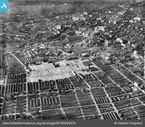
EPW055076 ENGLAND (1937). Slum clearance around George Street and environs, Manchester, 1937
© Copyright OpenStreetMap contributors and licensed by the OpenStreetMap Foundation. 2024. Cartography is licensed as CC BY-SA.
Nearby Images (10)
Details
| Title | [EPW055076] Slum clearance around George Street and environs, Manchester, 1937 |
| Reference | EPW055076 |
| Date | August-1937 |
| Link | |
| Place name | MANCHESTER |
| Parish | |
| District | |
| Country | ENGLAND |
| Easting / Northing | 383712, 397300 |
| Longitude / Latitude | -2.2454125992661, 53.471928381085 |
| National Grid Reference | SJ837973 |
Pins
 Stevieblue52 |
Monday 8th of June 2015 02:50:31 AM | |
 Stevieblue52 |
Monday 8th of June 2015 02:26:19 AM | |
 Stevieblue52 |
Monday 8th of June 2015 02:23:14 AM | |
 Stevieblue52 |
Monday 8th of June 2015 02:18:28 AM | |
 Stevieblue52 |
Monday 8th of June 2015 02:14:16 AM | |
 Stevieblue52 |
Monday 8th of June 2015 02:11:24 AM | |
 bescotbeast |
Wednesday 19th of March 2014 03:40:42 PM | |
 IvanSherratt |
Wednesday 31st of July 2013 11:55:14 PM | |
 IvanSherratt |
Wednesday 31st of July 2013 11:51:01 PM | |
 IvanSherratt |
Wednesday 31st of July 2013 11:43:07 PM | |
 IvanSherratt |
Wednesday 31st of July 2013 11:40:36 PM | |
 IvanSherratt |
Wednesday 31st of July 2013 11:32:57 PM | |
 IvanSherratt |
Wednesday 31st of July 2013 11:32:17 PM |


![[EPW055076] Slum clearance around George Street and environs, Manchester, 1937](http://britainfromabove.org.uk/sites/all/libraries/aerofilms-images/public/100x100/EPW/055/EPW055076.jpg)
![[EPW062699] Slum clearance around George Street, the Gaythorn Gas Works and environs, Manchester, 1939](http://britainfromabove.org.uk/sites/all/libraries/aerofilms-images/public/100x100/EPW/062/EPW062699.jpg)
![[EPW062710] The Gaythorn Gas Works, Manchester, 1939](http://britainfromabove.org.uk/sites/all/libraries/aerofilms-images/public/100x100/EPW/062/EPW062710.jpg)
![[EPW062698] Slum clearance around George Street, the Gaythorn Gas Works and environs, Manchester, 1939](http://britainfromabove.org.uk/sites/all/libraries/aerofilms-images/public/100x100/EPW/062/EPW062698.jpg)
![[EPW062700] The Gaythorn Gas Works and environs, Manchester, 1939](http://britainfromabove.org.uk/sites/all/libraries/aerofilms-images/public/100x100/EPW/062/EPW062700.jpg)
![[EPW062709] The Gaythorn Gas Works, Manchester, 1939](http://britainfromabove.org.uk/sites/all/libraries/aerofilms-images/public/100x100/EPW/062/EPW062709.jpg)
![[EPW062708] The Gaythorn Gas Works, Manchester, 1939](http://britainfromabove.org.uk/sites/all/libraries/aerofilms-images/public/100x100/EPW/062/EPW062708.jpg)
![[EPW005946] The Central Station and Albion Street area, Manchester, 1921](http://britainfromabove.org.uk/sites/all/libraries/aerofilms-images/public/100x100/EPW/005/EPW005946.jpg)
![[EPW062697] Slum clearance around George Street, the Gaythorn Gas Works and environs, Manchester, 1939](http://britainfromabove.org.uk/sites/all/libraries/aerofilms-images/public/100x100/EPW/062/EPW062697.jpg)
![[EPW060539] Slum clearance around George Street and environs, Manchester, 1939](http://britainfromabove.org.uk/sites/all/libraries/aerofilms-images/public/100x100/EPW/060/EPW060539.jpg)