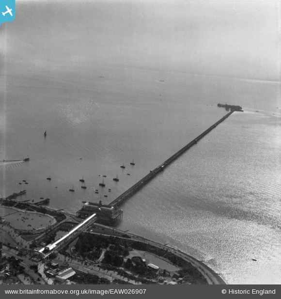
EAW026907 ENGLAND (1949). Southend Pier, Southend-on-Sea, from the north-west, 1949. This image has been produced from a print.
© Hawlfraint cyfranwyr OpenStreetMap a thrwyddedwyd gan yr OpenStreetMap Foundation. 2025. Trwyddedir y gartograffeg fel CC BY-SA.
Delweddau cyfagos (42)
Manylion
| Pennawd | [EAW026907] Southend Pier, Southend-on-Sea, from the north-west, 1949. This image has been produced from a print. |
| Cyfeirnod | EAW026907 |
| Dyddiad | 2-October-1949 |
| Dolen | |
| Enw lle | SOUTHEND-ON-SEA |
| Plwyf | |
| Ardal | |
| Gwlad | ENGLAND |
| Dwyreiniad / Gogleddiad | 588411, 184908 |
| Hydred / Lledred | 0.71669774245126, 51.531114611319 |
| Cyfeirnod Grid Cenedlaethol | TQ884849 |
Pinnau
Byddwch y cyntaf i ychwanegu sylw at y ddelwedd hon!


![[EAW026907] Southend Pier, Southend-on-Sea, from the north-west, 1949. This image has been produced from a print.](http://britainfromabove.org.uk/sites/all/libraries/aerofilms-images/public/100x100/EAW/026/EAW026907.jpg)
![[EPW037020] The Pier Pavilion, Marine Gardens and Palace Hotel, Southend-on-Sea, from the south-east, 1931](http://britainfromabove.org.uk/sites/all/libraries/aerofilms-images/public/100x100/EPW/037/EPW037020.jpg)
![[EAW002203] The Pier Pavilion, Royal Hill and the town, Southend-on-Sea, from the south-west, 1946](http://britainfromabove.org.uk/sites/all/libraries/aerofilms-images/public/100x100/EAW/002/EAW002203.jpg)
![[EPW000551] Southend-on-Sea, from the south, 1920](http://britainfromabove.org.uk/sites/all/libraries/aerofilms-images/public/100x100/EPW/000/EPW000551.jpg)
![[EPW062740] The Southend Pier Pavilion, Marine Gardens and the Boating Pool, Southend-on-Sea, 1939](http://britainfromabove.org.uk/sites/all/libraries/aerofilms-images/public/100x100/EPW/062/EPW062740.jpg)
![[EAW002202] The Pier Pavilion, Royal Hill and the town, Southend-on-Sea, 1946](http://britainfromabove.org.uk/sites/all/libraries/aerofilms-images/public/100x100/EAW/002/EAW002202.jpg)
![[EPW037015] The Pier Pavilion, Boating Pool, Palace Hotel and environs, Southend-on-Sea, from the south-east, 1931](http://britainfromabove.org.uk/sites/all/libraries/aerofilms-images/public/100x100/EPW/037/EPW037015.jpg)
![[EAW053089] The Pier Pavilion and Boating Pool, Southend-on-Sea, 1954](http://britainfromabove.org.uk/sites/all/libraries/aerofilms-images/public/100x100/EAW/053/EAW053089.jpg)
![[EPW062739] The Southend Pier Pavilion, Marine Gardens and the Boating Pool, Southend-on-Sea, 1939](http://britainfromabove.org.uk/sites/all/libraries/aerofilms-images/public/100x100/EPW/062/EPW062739.jpg)
![[EAW002199] Marine Gardens, Boating Pool, the Pier Pavilion and Marine Parade, Southend-on-Sea, 1946](http://britainfromabove.org.uk/sites/all/libraries/aerofilms-images/public/100x100/EAW/002/EAW002199.jpg)
![[EPW024885] The Pier Pavilion, Palace Hotel and town beyond, Southend-on-Sea, from the south, 1928](http://britainfromabove.org.uk/sites/all/libraries/aerofilms-images/public/100x100/EPW/024/EPW024885.jpg)
![[EAW026906] Southend Pier, Southend-on-Sea, from the north, 1949. This image has been produced from a print.](http://britainfromabove.org.uk/sites/all/libraries/aerofilms-images/public/100x100/EAW/026/EAW026906.jpg)
![[EAW002198] Marine Gardens, Boating Pool and the Pier Pavilion, Southend-on-Sea, 1946](http://britainfromabove.org.uk/sites/all/libraries/aerofilms-images/public/100x100/EAW/002/EAW002198.jpg)
![[EAW002200] Marine Gardens, Boating Pool and the Pier Pavilion, Southend-on-Sea, 1946](http://britainfromabove.org.uk/sites/all/libraries/aerofilms-images/public/100x100/EAW/002/EAW002200.jpg)
![[EPW000448] Marine Gardens and Palace Hotel, Southend-on-Sea, from the south-west, 1920](http://britainfromabove.org.uk/sites/all/libraries/aerofilms-images/public/100x100/EPW/000/EPW000448.jpg)
![[EAW002201] The Boating Pool, Pier Pavilion and environs, Southend-on-Sea, 1946](http://britainfromabove.org.uk/sites/all/libraries/aerofilms-images/public/100x100/EAW/002/EAW002201.jpg)
![[EAW026899] The Pier Pavilion and Marine Gardens, Southend-on-Sea, from the south-east, 1949. This image was marked by Aerofilms Ltd for photo editing.](http://britainfromabove.org.uk/sites/all/libraries/aerofilms-images/public/100x100/EAW/026/EAW026899.jpg)
![[EPW062738] The Southend Pier Pavilion, Marine Gardens and the Boating Pool, Southend-on-Sea, 1939](http://britainfromabove.org.uk/sites/all/libraries/aerofilms-images/public/100x100/EPW/062/EPW062738.jpg)
![[EAW002217] The Boating Pool, Southend-on-Sea, 1946](http://britainfromabove.org.uk/sites/all/libraries/aerofilms-images/public/100x100/EAW/002/EAW002217.jpg)
![[EPW000553] Southend-on-Sea, from the south-east, 1920](http://britainfromabove.org.uk/sites/all/libraries/aerofilms-images/public/100x100/EPW/000/EPW000553.jpg)
![[EAW024662] Marine Gardens, Royal Hill and the town, Southend-on-Sea, from the south-east, 1949](http://britainfromabove.org.uk/sites/all/libraries/aerofilms-images/public/100x100/EAW/024/EAW024662.jpg)
![[EPW000550] Southend-on-Sea, from the south-east, 1920](http://britainfromabove.org.uk/sites/all/libraries/aerofilms-images/public/100x100/EPW/000/EPW000550.jpg)
![[EPW032893] The Palace Hotel and Pier Pavilion, Southend-on-Sea, 1930](http://britainfromabove.org.uk/sites/all/libraries/aerofilms-images/public/100x100/EPW/032/EPW032893.jpg)
![[EPW000549] Southend-on-Sea, from the south-east, 1920](http://britainfromabove.org.uk/sites/all/libraries/aerofilms-images/public/100x100/EPW/000/EPW000549.jpg)
![[EPW024896] The Marine Gardens and Southend Pier Pavilion, Southend-on-Sea, 1928](http://britainfromabove.org.uk/sites/all/libraries/aerofilms-images/public/100x100/EPW/024/EPW024896.jpg)
![[EPW040967] The Southend Pier Pavilion, the Marine Gardens and the town, Southend-on-Sea, 1933](http://britainfromabove.org.uk/sites/all/libraries/aerofilms-images/public/100x100/EPW/040/EPW040967.jpg)
![[EAW043703] The Marine Gardens and Pier Pavilion, Southend-on-Sea, 1952](http://britainfromabove.org.uk/sites/all/libraries/aerofilms-images/public/100x100/EAW/043/EAW043703.jpg)
![[EPW062741] The Southend Pier Pavilion, Marine Gardens and the Boating Pool, Southend-on-Sea, 1939](http://britainfromabove.org.uk/sites/all/libraries/aerofilms-images/public/100x100/EPW/062/EPW062741.jpg)
![[EPW039868] Marine Gardens, the Pier Pavilion and Marine Parade, Southend-on-Sea, 1932](http://britainfromabove.org.uk/sites/all/libraries/aerofilms-images/public/100x100/EPW/039/EPW039868.jpg)
![[EAW002205] The Pier Pavilion, The Cliffs and the town, Southend-on-Sea, from the south-east, 1946](http://britainfromabove.org.uk/sites/all/libraries/aerofilms-images/public/100x100/EAW/002/EAW002205.jpg)
![[EPW062742] The Southend Pier Pavilion, Marine Gardens and the Boating Pool, Southend-on-Sea, 1939](http://britainfromabove.org.uk/sites/all/libraries/aerofilms-images/public/100x100/EPW/062/EPW062742.jpg)
![[EPW000441] Marine Gardens and Palace Hotel, Southend-on-Sea, 1920](http://britainfromabove.org.uk/sites/all/libraries/aerofilms-images/public/100x100/EPW/000/EPW000441.jpg)
![[EAW002218] The Boating Pool and sea front, Southend-on-Sea, 1946](http://britainfromabove.org.uk/sites/all/libraries/aerofilms-images/public/100x100/EAW/002/EAW002218.jpg)
![[EAW053087] The Marine Gardens and Royal Hill, Southend-on-Sea, 1954](http://britainfromabove.org.uk/sites/all/libraries/aerofilms-images/public/100x100/EAW/053/EAW053087.jpg)
![[EPW024892] The Palace Hotel and seafront, Southend-on-Sea, 1928](http://britainfromabove.org.uk/sites/all/libraries/aerofilms-images/public/100x100/EPW/024/EPW024892.jpg)
![[EPW037024] The Boating Pool, Seaway and environs, Southend-on-Sea, from the south-east, 1931](http://britainfromabove.org.uk/sites/all/libraries/aerofilms-images/public/100x100/EPW/037/EPW037024.jpg)
![[EPW036984] The Royal Terrace and the town, Southend-on-Sea, from the south, 1931](http://britainfromabove.org.uk/sites/all/libraries/aerofilms-images/public/100x100/EPW/036/EPW036984.jpg)
![[EPW036722] The Marine Gardens, the Western Esplanade and the town, Southend-on-Sea, from the south, 1931](http://britainfromabove.org.uk/sites/all/libraries/aerofilms-images/public/100x100/EPW/036/EPW036722.jpg)
![[EPW036705] The Southend-on-Sea Pier Pavilion, Marine Parade and the town, Southend-on-Sea, from the south, 1931](http://britainfromabove.org.uk/sites/all/libraries/aerofilms-images/public/100x100/EPW/036/EPW036705.jpg)
![[EPW036725] The Southend-on-Sea Pier Pavilion, the Marine Parade Boating Pool and St John the Baptist's Church, Southend-on-Sea, 1931](http://britainfromabove.org.uk/sites/all/libraries/aerofilms-images/public/100x100/EPW/036/EPW036725.jpg)
![[EPW054672] Marine Parade and the Boating Pool, Southend-on-Sea, 1937](http://britainfromabove.org.uk/sites/all/libraries/aerofilms-images/public/100x100/EPW/054/EPW054672.jpg)
![[EAW053099] The Shrubbery and Royal Terrace, Southend-on-Sea, 1954](http://britainfromabove.org.uk/sites/all/libraries/aerofilms-images/public/100x100/EAW/053/EAW053099.jpg)